IMAGES TAKEN NEAR TO
Clayton Street West, NEWCASTLE UPON TYNE, NE1 5BT
Introduction
This page details the photographs taken nearby to Clayton Street West, NE1 5BT by members of the Geograph project.
The Geograph project started in 2005 with the aim of publishing, organising and preserving representative images for every square kilometre of Great Britain, Ireland and the Isle of Man.

There are currently over 7.5m images from over14,400 individuals and you can help contribute to the project by visiting https://www.geograph.org.uk
Image Map (Loading...)


Getting Data...Please wait
Leaflet Map data © OpenStreetMap
Images are licensed for reuse under creativecommons.org/licenses/by-sa/2.0
Notes
- Clicking on the map will re-center to the selected point.
- The higher the marker number, the further away the image location is from the centre of the postcode.
Image Listing (1582 Images Found)
Images are licensed for reuse under creativecommons.org/licenses/by-sa/2.0
Image
Details
Distance
1
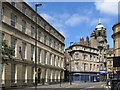
Clayton Street West / Pink Lane, NE1
Shows the location of the Image (left, between two first floor windows). Also shows the location of the Image (right, again at first floor level).
Image: © Mike Quinn
Taken: 5 Jun 2018
0.00 miles
2
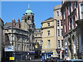
Clayton Street West, NE1
Looking north from the junction with Bewick Street with Image on the right, Image beyond on the corner with Pink Lane, and Image and its Image on the left.
Image: © Mike Quinn
Taken: 22 Apr 2015
0.01 miles
3
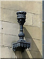
Metal bracket on wall, Clayton Street West, NE1
The location of this bracket is shown in Image
Image: © Mike Quinn
Taken: 5 Jun 2018
0.01 miles
4
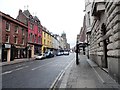
View up Westgate Road
This street was the main route west out of medieval Newcastle and follows the line of Hadrian's Wall. Hence the straight lines. Picture taken from beside Cross House, on the right.
Image: © Robert Graham
Taken: 2 Jan 2020
0.01 miles
5
Pink Lane from Westgate Road
There is a 'space invader' mosaic on the left wall from the Invasion of Newcastle 2nd wave, July 2006 http://www.space-invaders.com/sominv.html
Image: © Andrew Curtis
Taken: 24 Mar 2010
0.02 miles
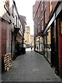
6
Pink Lane, NE1
Photo shows that part of the lane immediately south of Westgate Road. On the right is Image
Image: © Mike Quinn
Taken: 19 Nov 2013
0.02 miles
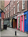
7

Ceramic tile public artwork, Pink Lane, NE1
There's just one tile missing (top left). This "space invader" was complete when I previously photographed Pink Lane in November 2013 Image See also my contemporaneous photo Image Andrew Curtis's extensive set of photos of the space invaders, including this one, is at http://www.geograph.org.uk/search.php?i=81864728 .
Image: © Mike Quinn
Taken: 20 Feb 2018
0.02 miles
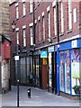
8
Pink Lane, NE1
Image: © Mike Quinn
Taken: 20 Feb 2018
0.02 miles
9

The PINK LANE BAKERY, Pink Lane, NE1
Image: © Mike Quinn
Taken: 20 Feb 2018
0.02 miles
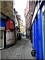
10
Pink Lane looking to Clayton Street
Pink Lane is an ancient street that ran behind the medieval town walls of Newcastle. It can be seen continuing on the far side of Clayton Street, from where it runs down to Neville Street, opposite the Central Station. The name comes from the Pink Tower on the wall. Despite its narrow width, it still has plenty of shops.
Image: © Robert Graham
Taken: 27 Aug 2019
0.02 miles