IMAGES TAKEN NEAR TO
Throckley, NEWCASTLE UPON TYNE, NE15 9RD
Introduction
This page details the photographs taken nearby to NE15 9RD by members of the Geograph project.
The Geograph project started in 2005 with the aim of publishing, organising and preserving representative images for every square kilometre of Great Britain, Ireland and the Isle of Man.

There are currently over 7.5m images from over14,400 individuals and you can help contribute to the project by visiting https://www.geograph.org.uk
Image Map
Images are licensed for reuse under creativecommons.org/licenses/by-sa/2.0
Notes
- Clicking on the map will re-center to the selected point.
- The higher the marker number, the further away the image location is from the centre of the postcode.
Image Listing (17 Images Found)
Images are licensed for reuse under creativecommons.org/licenses/by-sa/2.0
Image
Details
Distance
1
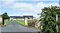
Callerton Grange
An impressive collection of buildings with the farm's access road along which runs a public footpath.
Image: © Trevor Littlewood
Taken: 23 Aug 2019
0.01 miles
2
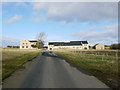
New house development at Callerton Grange
Image: © Andrew Curtis
Taken: 22 Feb 2009
0.02 miles
4
Reservoir
Large Covered Reservoir
Location Ponteland
Image: © peter maddison
Taken: 29 Oct 2010
0.12 miles
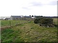
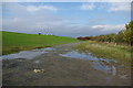
5
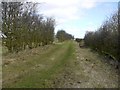
Footpath north of Callerton Grange
On the line of an old green lane.
Image: © Andrew Curtis
Taken: 22 Feb 2009
0.13 miles
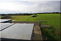
6
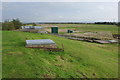
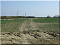
Throckley Marsh
Four small rectangular fields below the farm retain narrow ridge and furrow of post-medieval ploughing, clearly visible on aerial photographs.
Image: © Andrew Curtis
Taken: 26 Dec 2013
0.14 miles
7
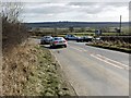
Busy road junction near Callerton Grange
Image: © Andrew Curtis
Taken: 22 Feb 2009
0.15 miles
8
Reservoir
Large covered reservoir
Location Ponteland
Image: © peter maddison
Taken: 29 Oct 2010
0.19 miles
9
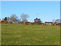
Callerton Common
Farmland off Stamfordham Road.
Image: © JThomas
Taken: 9 Apr 2015
0.19 miles
10
Reservoir and Road
Road in to Large Covered Reservoir
Location Ponteland
Image: © peter maddison
Taken: 29 Oct 2010
0.20 miles