IMAGES TAKEN NEAR TO
Hexham Road, NEWCASTLE UPON TYNE, NE15 9QU
Introduction
This page details the photographs taken nearby to Hexham Road, NE15 9QU by members of the Geograph project.
The Geograph project started in 2005 with the aim of publishing, organising and preserving representative images for every square kilometre of Great Britain, Ireland and the Isle of Man.

There are currently over 7.5m images from over14,400 individuals and you can help contribute to the project by visiting https://www.geograph.org.uk
Image Map (Loading...)


Getting Data...Please wait
Leaflet Map data © OpenStreetMap
Images are licensed for reuse under creativecommons.org/licenses/by-sa/2.0
Notes
- Clicking on the map will re-center to the selected point.
- The higher the marker number, the further away the image location is from the centre of the postcode.
Image Listing (47 Images Found)
Images are licensed for reuse under creativecommons.org/licenses/by-sa/2.0
Image
Details
Distance
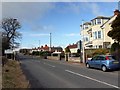
1
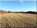
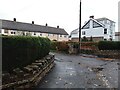
Field south of Hexham Road, Throckley
Hexham Road is on the left. It started life as the Military Road built on the foundations of Hadrian's Wall. The Vallum, running south of the Wall runs parallel to it through this field but ploughing has reduced its profile making it difficult to see here even in good light conditions. The houses at Throckley Bank Top are just visible at the far end of the field.
Image: © Andrew Curtis
Taken: 22 Nov 2013
0.03 miles
2
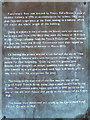
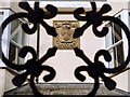
Plaque, Frenchman's Row (detail)
This is the story.
Image: © Alan Fearon
Taken: 21 Nov 2005
0.06 miles
3
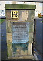
Plaque, Frenchman's Row, Throckley
This old gatepost, now in front of a line of very ordinary houses, tells a fascinating story about the original buildings on the site. For a close-up, see the supplemental image.
Image: © Alan Fearon
Taken: 21 Nov 2005
0.06 miles
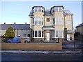
4
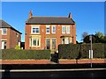
'Tyne View', Hexham Road, Throckley
The house is dated 1910.
Image: © Andrew Curtis
Taken: 26 Dec 2013
0.07 miles
5
Frenchmen's Row, Heddon on the Wall
The garden wall on the left is suitably crennelated owing to its location on the Throckley Road, a section of the Military Road built in the 1750s, on top of Hadrian's Wall.
Image: © Andrew Curtis
Taken: 28 Oct 2022
0.07 miles
6
Former Frenchman's Arms, Hexham Road, Heddon on the Wall
The building was formerly the Frenchman's Arms public house, now converted into apartments. The detail on the front wall is shown here Image
Frenchman's Row can be seen on the left Image
http://heddonhistory.weebly.com/frenchmans-row.html
Image: © Andrew Curtis
Taken: 21 Jan 2011
0.07 miles
7
The Royal French Arms, Heddon on the Wall
Motif retained on the front of the former pub on Hexham Road, Heddon on the Wall Image
The story of the Frenchmen of Heddon on the Wall can be found here http://heddonhistory.weebly.com/frenchmans-row.html
Image: © Andrew Curtis
Taken: 21 Jan 2011
0.07 miles
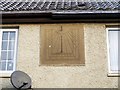
8
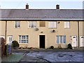
Frenchmen's Row, Heddon on the Wall
The story of Frenchmen's Row can be read here Image
The houses in the terrace now were built in 1962 when the original cottages were demolished. The sundial was re-erected over the doorway.
http://heddonhistory.weebly.com/frenchmans-row.html
Image: © Andrew Curtis
Taken: 21 Jan 2011
0.09 miles
9
Hexham Road, Throckley
The sign on the left shows the boundary between Throckley (Tyne & Wear) and Heddon on the Wall (Northumberland). The building on the right was the Frenchman's Arms Public House http://sine.ncl.ac.uk/view_image.asp?digital_doc_id=1616 built on the site of an even older Inn and now converted to flats.
The terrace beyond, and slightly behind, is still known as Frenchman's Row Image
There is an article about Frenchman's Row here http://heddonhistory.weebly.com/frenchmans-row.html https://web.archive.org/web/20200226120359/http://heddonhistory.weebly.com/frenchmans-row.html
Image: © Andrew Curtis
Taken: 22 Feb 2009
0.09 miles
10
Sundial, Frenchmen's Row
Another view and the story of the Frenchmen of Heddon on the Wall here Image
http://heddonhistory.weebly.com/frenchmans-row.html
Image: © Andrew Curtis
Taken: 21 Jan 2011
0.09 miles