IMAGES TAKEN NEAR TO
Winshields Way, NEWCASTLE UPON TYNE, NE15 9QN
Introduction
This page details the photographs taken nearby to Winshields Way, NE15 9QN by members of the Geograph project.
The Geograph project started in 2005 with the aim of publishing, organising and preserving representative images for every square kilometre of Great Britain, Ireland and the Isle of Man.

There are currently over 7.5m images from over14,400 individuals and you can help contribute to the project by visiting https://www.geograph.org.uk
Image Map (Loading...)


Getting Data...Please wait
Leaflet Map data © OpenStreetMap
Images are licensed for reuse under creativecommons.org/licenses/by-sa/2.0
Notes
- Clicking on the map will re-center to the selected point.
- The higher the marker number, the further away the image location is from the centre of the postcode.
Image Listing (25 Images Found)
Images are licensed for reuse under creativecommons.org/licenses/by-sa/2.0
Image
Details
Distance
1

Path from Coach Road to Holeyn Road, Throckley
Image: © Andrew Curtis
Taken: 14 Nov 2013
0.07 miles
2

Coach Road, Throckley
The driveway to Throckley House is on the right, leading into the trees. Another lane runs directly to its right which may be the route of a former waggonway leading north of South Farm.
Image: © Andrew Curtis
Taken: 14 Nov 2013
0.08 miles

4
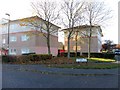
Apartment blocks on corner of Tillmouth Park Road & Hawkwell Rise, Throckley
Image: © Andrew Curtis
Taken: 14 Nov 2013
0.11 miles
5
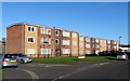
Apartment blocks, Tillmouth Park Road, Throckley
Image: © Andrew Curtis
Taken: 14 Nov 2013
0.11 miles

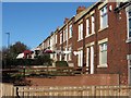
8

Lane west of Coach Road, Throckley
The entrance drive to Throckley House is on the left. This lane is probably on the route of a former colliery waggonway leading to the west. Its level has been embanked and is higher than the field behind the trees on the left.
Image: © Andrew Curtis
Taken: 14 Nov 2013
0.12 miles
9
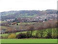
Throckley & Heddon from above Walbottle
Image: © Andrew Curtis
Taken: 1 Dec 2013
0.14 miles
10
Throckley Primary Care Centre, Tillmouth Park Road
Image: © Andrew Curtis
Taken: 14 Nov 2013
0.15 miles