IMAGES TAKEN NEAR TO
Northway, NEWCASTLE UPON TYNE, NE15 9EY
Introduction
This page details the photographs taken nearby to Northway, NE15 9EY by members of the Geograph project.
The Geograph project started in 2005 with the aim of publishing, organising and preserving representative images for every square kilometre of Great Britain, Ireland and the Isle of Man.

There are currently over 7.5m images from over14,400 individuals and you can help contribute to the project by visiting https://www.geograph.org.uk
Image Map (Loading...)


Getting Data...Please wait
Leaflet Map data © OpenStreetMap
Images are licensed for reuse under creativecommons.org/licenses/by-sa/2.0
Notes
- Clicking on the map will re-center to the selected point.
- The higher the marker number, the further away the image location is from the centre of the postcode.
Image Listing (42 Images Found)
Images are licensed for reuse under creativecommons.org/licenses/by-sa/2.0
Image
Details
Distance
1
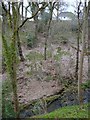
Walbottle Dene
Looking over the steep slopes of the Dene to the backs of the houses on Woodside Avenue.
Image: © Andrew Curtis
Taken: 1 Apr 2011
0.13 miles
2
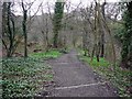
Path into Walbottle Dene from Hexham Road
Image: © Andrew Curtis
Taken: 1 Apr 2011
0.14 miles
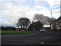
4
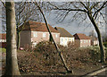
Houses in Throckley
Houses viewed from the Co-op car park.
Image: © Helen Wilkinson
Taken: 7 Feb 2008
0.14 miles
5
Throckley, Newcastle-upon -Tyne
The south face of the War Memorial that is located adjacent to the Church of St. Mary the Virgin, Throckley.
Image: © Philip Soakell
Taken: 25 Jun 2009
0.15 miles
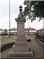
6
Throckley, Newcastle-upon -Tyne
The west face of the War Memorial that is located adjacent to the Church of St. Mary the Virgin, Throckley.
Image: © Philip Soakell
Taken: 25 Jun 2009
0.15 miles
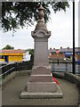
7
Throckley, Newcastle-upon -Tyne
The east face of the War Memorial that is located adjacent to the Church of St Mary the Virgin, Throckley.
Image: © Philip Soakell
Taken: 25 Jun 2009
0.15 miles
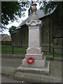
8
Throckley, Newcastle-upon -Tyne
The north face of the War Memorial that is located adjacent to the Church of St. Mary the Virgin, Throckley.
Image: © Philip Soakell
Taken: 25 Jun 2009
0.15 miles
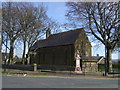
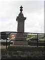
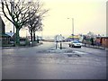
9
Roundabout, Church and War Memorial. Throckley
Image: © Les Hull
Taken: 20 Nov 2013
0.15 miles
10
Newburn Road, Throckley
Taken from the roundabout at the junction with Hexham Road. St Mary's Church is on the left Image The small building behind the car is the only reminder of the Lyric Cinema which used to be at this junction. The store is called, 'Lyric Wines'. The Lyric Cinema opened in 1935 and closed in 1966.
There are photos in the Newcastle Libraries collection here http://www.flickr.com/photos/newcastlelibraries/4084947095/ and http://www.flickr.com/photos/newcastlelibraries/4090995482/
Image: © Andrew Curtis
Taken: 21 Jan 2011
0.15 miles