IMAGES TAKEN NEAR TO
Osprey Avenue, NE15 9DN
Introduction
This page details the photographs taken nearby to Osprey Avenue, NE15 9DN by members of the Geograph project.
The Geograph project started in 2005 with the aim of publishing, organising and preserving representative images for every square kilometre of Great Britain, Ireland and the Isle of Man.

There are currently over 7.5m images from over14,400 individuals and you can help contribute to the project by visiting https://www.geograph.org.uk
Image Map
Images are licensed for reuse under creativecommons.org/licenses/by-sa/2.0
Notes
- Clicking on the map will re-center to the selected point.
- The higher the marker number, the further away the image location is from the centre of the postcode.
Image Listing (7 Images Found)
Images are licensed for reuse under creativecommons.org/licenses/by-sa/2.0
Image
Details
Distance
1
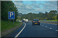
Throckley : A69
Looking along the A69.
Image: © Lewis Clarke
Taken: 25 Sep 2020
0.05 miles
2
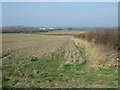
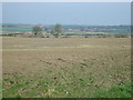
Field and hedgerow
West of North Walbottle Road.
Image: © JThomas
Taken: 9 Apr 2015
0.14 miles
3
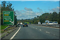
Throckley : A69
Looking along the A69.
Image: © Lewis Clarke
Taken: 25 Sep 2020
0.15 miles
4
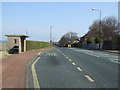
Bus stop and shelter on North Walbottle Road
Looking north.
Image: © JThomas
Taken: 9 Apr 2015
0.17 miles
5
Farmland, North Walbottle Road
West of North Walbottle Road.
Image: © JThomas
Taken: 9 Apr 2015
0.18 miles
6
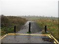
Former North Walbottle Road
Old road now blocked off
Image: © Alex McGregor
Taken: 22 Nov 2011
0.23 miles