IMAGES TAKEN NEAR TO
Dewley Court, NEWCASTLE UPON TYNE, NE15 9AW
Introduction
This page details the photographs taken nearby to Dewley Court, NE15 9AW by members of the Geograph project.
The Geograph project started in 2005 with the aim of publishing, organising and preserving representative images for every square kilometre of Great Britain, Ireland and the Isle of Man.

There are currently over 7.5m images from over14,400 individuals and you can help contribute to the project by visiting https://www.geograph.org.uk
Image Map
Images are licensed for reuse under creativecommons.org/licenses/by-sa/2.0
Notes
- Clicking on the map will re-center to the selected point.
- The higher the marker number, the further away the image location is from the centre of the postcode.
Image Listing (20 Images Found)
Images are licensed for reuse under creativecommons.org/licenses/by-sa/2.0
Image
Details
Distance
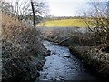
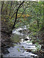
2
Triple culvert on the Dewley Burn
A triple culvert carries the Dewley Burn under the main A69 road (on top of the embankment seen in the background). The upper culvert presumably only becomes operational in times of flood. Below here, the burn flows through Throckley Dene.
Image: © Oliver Dixon
Taken: 1 Feb 2013
0.10 miles
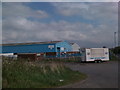
3
Industrial Estate, Throckley
Army vehicle parked
Image: © Les Hull
Taken: 20 Nov 2013
0.10 miles
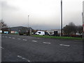
5

Westway Industrial Park
Not all squares can be interesting!!
Image: © Phil Thirkell
Taken: 11 Jan 2006
0.11 miles
6
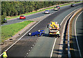
A69
A RTC on the A69 near Throckley.
Image: © Peter McDermott
Taken: 4 Sep 2011
0.12 miles
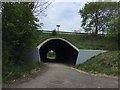
8
Underpass under the A69
See another photo here Image
Image: © Andrew Curtis
Taken: 26 Dec 2013
0.16 miles
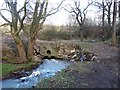
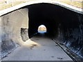
10
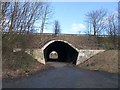
Underpass under the A69
A farm road passes under the A69 (Newcastle to Carlisle road) at the head of Throckley Dene.
Image: © Oliver Dixon
Taken: 1 Feb 2013
0.19 miles