IMAGES TAKEN NEAR TO
Shamrock Close, NEWCASTLE UPON TYNE, NE15 8TW
Introduction
This page details the photographs taken nearby to Shamrock Close, NE15 8TW by members of the Geograph project.
The Geograph project started in 2005 with the aim of publishing, organising and preserving representative images for every square kilometre of Great Britain, Ireland and the Isle of Man.

There are currently over 7.5m images from over14,400 individuals and you can help contribute to the project by visiting https://www.geograph.org.uk
Image Map
Images are licensed for reuse under creativecommons.org/licenses/by-sa/2.0
Notes
- Clicking on the map will re-center to the selected point.
- The higher the marker number, the further away the image location is from the centre of the postcode.
Image Listing (26 Images Found)
Images are licensed for reuse under creativecommons.org/licenses/by-sa/2.0
Image
Details
Distance
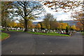
1
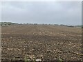
Crop field and hedgerow
South of Hawthorn Terrace (B6528).
Image: © JThomas
Taken: 9 Apr 2015
0.12 miles
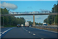
4
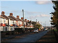
Westlands, NE15 (2)
The road lies on the line of Hadrian's Wall - see the map and satellite image http://openspace.nearby.org.uk/wheresthepath.htm?lat=54.98925532516082&lon=-1.7140817642211914&gz=17&oz=10>=1. The site of Turret 8b lies in the foreground.
Image: © Mike Quinn
Taken: 1 Nov 2011
0.16 miles
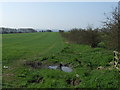
5
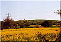
Knop Law
Looking over fields towards Knop Law.
Image: © Chris Bell
Taken: 7 May 2000
0.17 miles
9
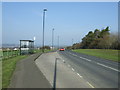
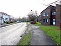
Bus stop and shelter on Hawthorn Terrace (B6528)
Image: © JThomas
Taken: 9 Apr 2015
0.19 miles