IMAGES TAKEN NEAR TO
Rokeby Avenue, NEWCASTLE UPON TYNE, NE15 8AE
Introduction
This page details the photographs taken nearby to Rokeby Avenue, NE15 8AE by members of the Geograph project.
The Geograph project started in 2005 with the aim of publishing, organising and preserving representative images for every square kilometre of Great Britain, Ireland and the Isle of Man.

There are currently over 7.5m images from over14,400 individuals and you can help contribute to the project by visiting https://www.geograph.org.uk
Image Map (Loading...)


Getting Data...Please wait
Leaflet Map data © OpenStreetMap
Images are licensed for reuse under creativecommons.org/licenses/by-sa/2.0
Notes
- Clicking on the map will re-center to the selected point.
- The higher the marker number, the further away the image location is from the centre of the postcode.
Image Listing (10 Images Found)
Images are licensed for reuse under creativecommons.org/licenses/by-sa/2.0
Image
Details
Distance
3

The Lemington Centre, Tyne View, Lemington
The new building incorporates a Children's Centre and a Healthy Living Centre. It was opened in 2005 and is manned by volunteers from Lemington Community Association http://www.lemingtoncentre.co.uk/
Image: © Andrew Curtis
Taken: 28 Jul 2010
0.22 miles
4

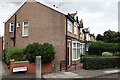
Tyne View, Lemington
Despite its name, the road doesn't seem to offer views of the river. The shop on the corner of Montague Street is a butchers.
Image: © Gerald England
Taken: 19 Oct 2022
0.22 miles
5

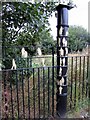
William Pym's 'Lightbulb', Lemington Centre
The 3m tall light bulb by William Pym (2004-5) is illuminated at night by fibre optics.
The same artist was commissioned for other nearby art works Image
As well as the 'thinking' connotation of the light bulb, there is also a connection with past local industry. Although originally designed for the manufacture of flat glass, in 1906, ownership of the nearby Lemington Glassworks Image passed to the General Electric Company, who used the plant to produce light bulbs and tubes http://sine.ncl.ac.uk/view_structure_information.asp?struct_id=485
Image: © Andrew Curtis
Taken: 28 Jul 2010
0.23 miles
6

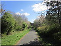
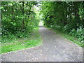
Hadrian's Cycleway
Sustrans National Cycle Network Route 72 here follows the line of Hadrian's Wall. It provides a pedestrian entrance to the nearby Lidl on Scottswood Road.
Image: © Gerald England
Taken: 19 Oct 2022
0.23 miles
8
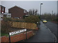
William Pym's Roman Fence, Lemington
The 65-metre long fence with gold painted silhouettes of Roman soldiers cost £29,000 and took several years before it was completed in 2007. Although close to the Hadrian’s Trail footpath and cycle route it is about a mile from the stretch of Hadrian's Wall that passes through Lemington to the north http://news.bbc.co.uk/1/hi/england/6336887.stm
Image: © Andrew Curtis
Taken: 28 Jul 2010
0.24 miles
9
The Hadrian's Wall Path at Lemington
Image: © David Purchase
Taken: 24 May 2013
0.24 miles
10

Hadrian's Cycleway
This section which is part of Sustran's National Cycle Network 72 https://www.sustrans.org.uk/find-other-routes/hadrians-cycleway follows the route of Hadrian's Wall.
Image: © Gerald England
Taken: 19 Oct 2022
0.25 miles