IMAGES TAKEN NEAR TO
Thorntree Drive, NEWCASTLE UPON TYNE, NE15 7AS
Introduction
This page details the photographs taken nearby to Thorntree Drive, NE15 7AS by members of the Geograph project.
The Geograph project started in 2005 with the aim of publishing, organising and preserving representative images for every square kilometre of Great Britain, Ireland and the Isle of Man.

There are currently over 7.5m images from over14,400 individuals and you can help contribute to the project by visiting https://www.geograph.org.uk
Image Map (Loading...)


Getting Data...Please wait
Leaflet Map data © OpenStreetMap
Images are licensed for reuse under creativecommons.org/licenses/by-sa/2.0
Notes
- Clicking on the map will re-center to the selected point.
- The higher the marker number, the further away the image location is from the centre of the postcode.
Image Listing (14 Images Found)
Images are licensed for reuse under creativecommons.org/licenses/by-sa/2.0
Image
Details
Distance
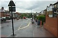
2
La Famiglia, Mozzarella and The Bindi, Whickham View
Image: © Anthony Foster
Taken: 31 Jul 2024
0.10 miles
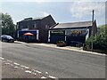
3

John Marley Centre, Whickham View, Benwell
Formerly, Whickham View Schools, dating from 1936-8, now part of Newcastle's West End College. A Grade II Listed Building https://historicengland.org.uk/listing/the-list/list-entry/1024807
There is another photo and description here Image
There is a statue of Sir John Marley (1590 - 1673) http://www.northumbria.info/Pages/marley.html in the city centre Image
Image: © Andrew Curtis
Taken: 23 Mar 2012
0.19 miles
5
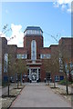
John Marley Centre, Scotswood, Newcastle upon Tyne
This lovely art deco building was built in 1936 as a secondary school, closed in 1992 and reopened in 1994 as part of Newcastle college, with local boy Mark Knopfler doing the honours.
It was named after Sir John Marley who defended the King's interest in the town during the Civil War and later became Mayor. During the 1644 Siege of Newcastle the Scots, in taking the town for Parliament, threatened to destroy the tower of St. Nicholas Church with cannon-fire to quell resistance. Sir John Marley proceeded to place Scottish prisoners within the structure to save its very existence - and save it he did!
Image: © hayley green
Taken: 29 Aug 2009
0.20 miles
6
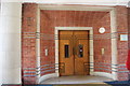
Interior door, John Marley College, Scotswood, Newcastle upon Tyne
Detail of the still lovely art deco finishings, esp like the way the trim on the brick is reflected and continued on the door
Image: © hayley green
Taken: 29 Aug 2009
0.21 miles
7
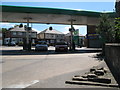
(A very small part of) Hadrian's Wall (2)
This is the first section of Hadrian's Wall to be seen to the west of Newcastle. It lies in the forecourt of a petrol station at the southwest of the roundabout at the junction of West Road and Denton Road.
Image: © Mike Quinn
Taken: 9 Jun 2008
0.22 miles
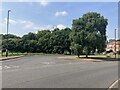
9
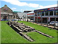
(Part of) Hadrian's Wall (2)
This section is about 25 yards west of Image
Image: © Mike Quinn
Taken: 9 Jun 2008
0.24 miles
10
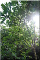
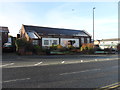
Little oak tree, Scotswood Community Garden, Newcastle upon Tyne
As well as growing lots of veg and fruit the idea of the garden project is to green this area and plant lots of native trees. The little oak tree was settling in well and looked very happy in his own glade
Image: © hayley green
Taken: 29 Aug 2009
0.24 miles