IMAGES TAKEN NEAR TO
Axwell Park View, NEWCASTLE UPON TYNE, NE15 6NQ
Introduction
This page details the photographs taken nearby to Axwell Park View, NE15 6NQ by members of the Geograph project.
The Geograph project started in 2005 with the aim of publishing, organising and preserving representative images for every square kilometre of Great Britain, Ireland and the Isle of Man.

There are currently over 7.5m images from over14,400 individuals and you can help contribute to the project by visiting https://www.geograph.org.uk
Image Map
Images are licensed for reuse under creativecommons.org/licenses/by-sa/2.0
Notes
- Clicking on the map will re-center to the selected point.
- The higher the marker number, the further away the image location is from the centre of the postcode.
Image Listing (24 Images Found)
Images are licensed for reuse under creativecommons.org/licenses/by-sa/2.0
Image
Details
Distance
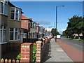
1
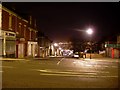
Delaval Road
In Benwell, west of Newcastle. At the bottom of the hill, the Gateshead MetroCentre - the largest shopping centre in the EU - can be seen.
Image: © Stephen Sweeney
Taken: 12 Jan 2009
0.02 miles
2
Benwell Lane
A 2009 view of Alan Murray-Rust's 1966 photograph Image The buildings to the right are in the process of being demolished.
Image: © Anthony Foster
Taken: 4 Apr 2009
0.10 miles
3
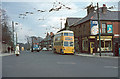
British Trolleybuses - Newcastle upon Tyne
A trolleybus arrives at was then the terminus of the Elswick Road service at Benwell. Earlier, services continued beyond this point to Denton. This is the junction of Benwell Lane with Delaval Road to the right. The trolleybus will pull forward across the junction and then reverse into Delaval Road before pulling on to the departure stop (behind the lollipop man). The idea of making this sort of manoeuvre in this day and age would be unthinkable, but at that stage it was still a common practice. The presence of the lollipop man shows that this would be school finishing time, but there is nothing like the amount of traffic that there would be today.
Postscript: even in 2009, the traffic seems to be quite light; the astonishing thing is how little the scene has changed Image
Postscript 2014: The scene has changed beyond recognition http://www.geograph.org.uk/photo/3905494
For a slide show of British Trolleybuses in the late 60s http://www.geograph.org.uk/search.php?i=1773236&displayclass=slide
Image: © Alan Murray-Rust
Taken: 25 Mar 1966
0.10 miles
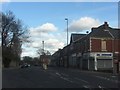
6
Benwell Lane
A 2014 update of earlier photographs in 1966 Image and 2009 Image The buildings on Benwell Lane and Delaval Road have been demolished.
Image: © Anthony Foster
Taken: 28 Feb 2014
0.11 miles
7
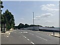
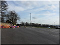
Armstrong Road from Wayside, Benwell
Looking down on the development site of Scotswood and Delaval, recently cleared and levelled before new house building starts.
Image: © Andrew Curtis
Taken: 23 Mar 2012
0.13 miles
8
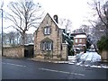
Lodge south of Wellburn House, Benwell Lane
This was formerly the lodge to Benwell Towers (recently The Mitre public house) and a listed building http://www.heritagegateway.org.uk/Gateway/Results_Single.aspx?uid=304399&resourceID=5
Image: © Andrew Curtis
Taken: 26 Nov 2010
0.14 miles
9
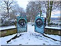
'Lovers Gate' by William Pym, Hodgkin Park
The ornamental gates are at the north entrance to the northerly section of Hodgkin Park on Benwell Lane. The wording in painted cut steel is 'From Lovers Lane to Gretna Road' and 'Lover's Refuge / Nature's Asylum'
A reflection of local place names and, I guess, the park's place in local life.
Public Monuments and Sculpture Association: http://www.pmsa.org.uk/pmsa-database/9558/
Image: © Andrew Curtis
Taken: 26 Nov 2010
0.14 miles
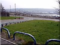
10
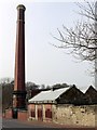
Benwell Water Pumping Station, Axwell Park Road
The pumping engine chimney was built in 1904 for the Newcastle and Gateshead Water Co. https://historicengland.org.uk/listing/the-list/list-entry/1186128
To the right of the chimney is the former lodge house built around 1857 for the Whittle Dean Water Company https://historicengland.org.uk/listing/the-list/list-entry/1024949
Although the lodge and chimney are no longer in use, the water pumping station was recently upgraded, providing a supply of drinking water to a large area of Newcastle's west end, via a large underground reservoirs behind. The earlier open reservoirs situated on the east side have been filled in and grassed over.
Image: © Andrew Curtis
Taken: 23 Mar 2012
0.16 miles