IMAGES TAKEN NEAR TO
Highcrofts, NEWCASTLE UPON TYNE, NE15 0PD
Introduction
This page details the photographs taken nearby to Highcrofts, NE15 0PD by members of the Geograph project.
The Geograph project started in 2005 with the aim of publishing, organising and preserving representative images for every square kilometre of Great Britain, Ireland and the Isle of Man.

There are currently over 7.5m images from over14,400 individuals and you can help contribute to the project by visiting https://www.geograph.org.uk
Image Map
Images are licensed for reuse under creativecommons.org/licenses/by-sa/2.0
Notes
- Clicking on the map will re-center to the selected point.
- The higher the marker number, the further away the image location is from the centre of the postcode.
Image Listing (73 Images Found)
Images are licensed for reuse under creativecommons.org/licenses/by-sa/2.0
Image
Details
Distance
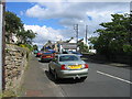
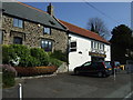
1
Milepost, Horsley
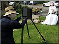
The metal milepost at the front of the house records the time that this was the original route of the main A69 before Heddon and Horsley were by-passed by a new dual carriageway in 1971. The building behind is known as the Dukes' Houses named for the Duke of Northumberland who owned 15 farms in the area in the 17th century.
Image: © Andrew Curtis
Taken: 10 Jan 2009
0.02 miles
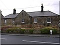
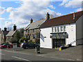
6
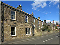
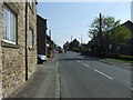
(Part of) Horsley
The north side of the main road through the village (now the B6528, originally the A69). The building with a gable end to the road (called Moor View, half right) is Grade II listed https://www.historicengland.org.uk/listing/the-list/list-entry/1154248 ; on the far right is Image
Image: © Mike Quinn
Taken: 26 Mar 2018
0.03 miles
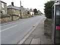
7
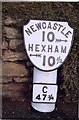
Old Milepost by the B6528, Main Street, Horsley Parish
Metal post with attached metal plate by the B6528, in parish of HORSLEY (CASTLE MORPETH District), Main Street, opposite Highcrofts junction, in footpath against stone retaining wall of garden, on North side of road. Smith Patterson iron shield, erected by the Hexham turnpike trust in the 19th century.
Inscription reads:-
NEWCASTLE
10 {arrow to right}
HEXHAM
{arrow to left} 10½
C
47¾
Maker:-
: SMITH PATTERSON / & CO / BLAYDON :
Milestone Society National ID: NB_NCHX10.
Image: © IA Davison
Taken: 1 May 2000
0.03 miles
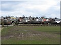
9
The Old Coach Station
For info about the building, which is Grade II listed https://www.historicengland.org.uk/listing/the-list/list-entry/1044978 , see Image (photographed by Andrew Curtis).
Image: © Mike Quinn
Taken: 26 Mar 2018
0.03 miles