IMAGES TAKEN NEAR TO
Forth Banks, NEWCASTLE UPON TYNE, NE1 3PN
Introduction
This page details the photographs taken nearby to Forth Banks, NE1 3PN by members of the Geograph project.
The Geograph project started in 2005 with the aim of publishing, organising and preserving representative images for every square kilometre of Great Britain, Ireland and the Isle of Man.

There are currently over 7.5m images from over14,400 individuals and you can help contribute to the project by visiting https://www.geograph.org.uk
Image Map (Loading...)


Getting Data...Please wait
Leaflet Map data © OpenStreetMap
Images are licensed for reuse under creativecommons.org/licenses/by-sa/2.0
Notes
- Clicking on the map will re-center to the selected point.
- The higher the marker number, the further away the image location is from the centre of the postcode.
Image Listing (766 Images Found)
Images are licensed for reuse under creativecommons.org/licenses/by-sa/2.0
Image
Details
Distance
1

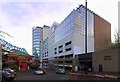
Hanover Mill, Metro Bridge & Forth Banks from Close
The west end of Close near the junction of Skinnerburn Road and Forth Banks has changed much and was once a densely packed industrial area. In 1827 there was the large Northumberland Flint-Glass Works, a brewery, a steam flour mill and Skinnerburn Iron Works. Forth Banks was described as 'a wide and commodious road conducts from its extremity up a bold ascent to the Infirmary and Forth'. The east side of Forth Banks, above Hanover Street, was the location of Hawthorn's Engine Works. Skinnerburn Road, below the steep bank terraced into garden plots, had timber yards and lime kilns, leading to the Elswick Lead Works and its prominent Shot Tower. Eneas Mackenzie (1827) http://www.british-history.ac.uk/report.aspx?compid=43343
Image: © Andrew Curtis
Taken: 5 Dec 2011
0.00 miles
2

Development at junction of Skinnerburn Road and Forth Banks
A 15-storey office and apartment block with associated multi-storey car park and accommodation blocks by Newcastle architects, Napper http://www.napperarchitects.net/napper-residential.html built in 2007-2009 http://www.skyscrapernews.com/buildings.php?id=1177
Currently the 15th tallest building/structure in Newcastle http://en.wikipedia.org/wiki/List_of_tallest_buildings_and_structures_in_Newcastle_upon_Tyne
The blue-painted Metro Bridge is reflected in the glass Image
Image: © Andrew Curtis
Taken: 5 Dec 2011
0.01 miles

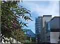
4

Metro Train, Newcastle
A Tyne & Wear Metro train about to cross the Tyne after emerging from the tunnelled section below central Newcastle.
Image: © David Robinson
Taken: 28 May 2019
0.02 miles
5
West 1 and Forth Banks Apartments, Forth Banks
Office, apartment and car parking new development at the bottom of Forth Banks opposite the Waterside Palace Chinese restaurant and Metro Railway Bridge. A wide angle view of Image
Image: © Andrew Curtis
Taken: 5 Dec 2011
0.02 miles
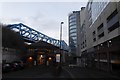
6

The Queen Elizabeth II Metro Bridge above Forth Banks, NE1
See Image
Image: © Mike Quinn
Taken: 10 Mar 2015
0.02 miles
7
Bridge and Buddleias
Looking down Forth Banks towards the Queen Elizabeth II (Metro) Bridge, with buddleias in full bloom. This area is so different from when I knew it in the 1960s, when my Dad worked for Rediffusion TV, whose Newcastle workshops were here. See also Image
Image: © Barbara Carr
Taken: 21 Jul 2012
0.03 miles
8
Mantra Thai Dining
Looking down Forth Banks towards the river, with one of the bridges prominent.
Image: © DS Pugh
Taken: 8 Jan 2017
0.03 miles
9

Bridge, Metro
Newly painted by the looks of it.
Image: © Richard Webb
Taken: 18 Jun 2013
0.03 miles
10
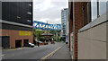
Forth Banks (B1600), Newcastle
The Queen Elizabeth II Bridge crosses the street in the background.
Image: © habiloid
Taken: 7 Aug 2021
0.03 miles