IMAGES TAKEN NEAR TO
Peppercorn Court, NEWCASTLE UPON TYNE, NE1 3HD
Introduction
This page details the photographs taken nearby to Peppercorn Court, NE1 3HD by members of the Geograph project.
The Geograph project started in 2005 with the aim of publishing, organising and preserving representative images for every square kilometre of Great Britain, Ireland and the Isle of Man.

There are currently over 7.5m images from over14,400 individuals and you can help contribute to the project by visiting https://www.geograph.org.uk
Image Map (Loading...)


Getting Data...Please wait
Leaflet Map data © OpenStreetMap
Images are licensed for reuse under creativecommons.org/licenses/by-sa/2.0
Notes
- Clicking on the map will re-center to the selected point.
- The higher the marker number, the further away the image location is from the centre of the postcode.
Image Listing (2298 Images Found)
Images are licensed for reuse under creativecommons.org/licenses/by-sa/2.0
Image
Details
Distance
1
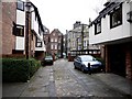
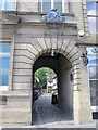
Broad Garth
There were no minor streets or 'chares' running off the Quayside before 1376, but after that date 20 are described between Sandhill and Sandgate which survived until the mid C19. Most were so narrow that two people could not walk abreast. The line of the twisting, narrow alley, Kirk Chare, is marked out here by the paving. Many of the chares in this area of the Quayside were destroyed in the Great Fire of 1854.
Broad Chare was an exception, as it was wide enough to take a cart. Modern development has now widened Broad Garth to just tolerate the odd car. The Quayside can be seen through the distant arch which is known as 'Fenwick's Entry'.
Image: © Andrew Curtis
Taken: 24 Jan 2010
0.01 miles
2
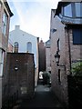
Chare behind Custom House Entry
The white building on the left is the rear of Image
The archway on the left side of its Quayside frontage provides access to this alley leading to Custom House Yard and the modern housing of Peppercorn Court Image
An 1827 document http://www.british-history.ac.uk/report.aspx?compid=43337 implies that the alley previously in this location may have been called Peacock's Chare. The buildings west of here were destroyed in the fire of 1854.
Image: © Andrew Curtis
Taken: 18 Nov 2010
0.01 miles
3

Newcastle Quayside from Sage forecourt
On the day before the Great North Run when various other races were being run on both banks of the Tyne.
Image: © Chris Morgan
Taken: 6 Sep 2014
0.02 miles
4
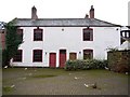
Trinity House almshouses, Trinity Chare
Almshouses, now a warehouse, built in 1820 for Trinity House.
Tyne and Wear HER (8728): Newcastle, Trinity Chare, Nos. 9 and 10, former Trinity House http://www.twsitelines.info
Image: © Andrew Curtis
Taken: 24 Jan 2010
0.02 miles
5
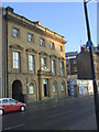
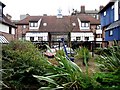
The Customs House, Quayside, Newcastle
Image: © Bill Henderson
Taken: 20 Feb 2010
0.02 miles
6
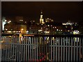
Newcastle from Gateshead
Looking across the city. The spire of the All Saints Church is most prominent.
Image: © Stephen Sweeney
Taken: 5 Jan 2009
0.02 miles
8
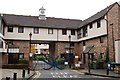
Peppercorn & Blue Anchor Courts, Broad Garth
A sensitive modern housing development in this historic, crowded area of Quayside.
The names are taken from two old chares that were destroyed in the great fire of 1854. The courtyard beyond the gateway in the centre of the photo is shown here Image
Image: © Andrew Curtis
Taken: 24 Jan 2010
0.02 miles
10

Quayside
The Newcastle Quayside seen from the Tyne Bridge.
Image: © Peter McDermott
Taken: 6 Mar 2011
0.02 miles