IMAGES TAKEN NEAR TO
Milk Market, NEWCASTLE UPON TYNE, NE1 3DN
Introduction
This page details the photographs taken nearby to Milk Market, NE1 3DN by members of the Geograph project.
The Geograph project started in 2005 with the aim of publishing, organising and preserving representative images for every square kilometre of Great Britain, Ireland and the Isle of Man.

There are currently over 7.5m images from over14,400 individuals and you can help contribute to the project by visiting https://www.geograph.org.uk
Image Map
Images are licensed for reuse under creativecommons.org/licenses/by-sa/2.0
Notes
- Clicking on the map will re-center to the selected point.
- The higher the marker number, the further away the image location is from the centre of the postcode.
Image Listing (1365 Images Found)
Images are licensed for reuse under creativecommons.org/licenses/by-sa/2.0
Image
Details
Distance
1
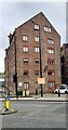
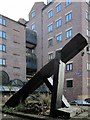
Former warehouse on south side of City Road at Milk Market
Image: © Roger Templeman
Taken: 5 May 2022
0.00 miles
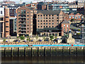
2
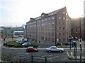
Milk Market, Newcastle Quayside
A view of the east side of Johnson Dodds warehouse building now converted into apartments Image 'The Waterline' public house is on the left hand side of the warehouse, facing the Quayside Image
The lyrics of the Dire Straits' song, 'Down to the Waterline', can be read here Image
The Milk Market takes its name from the daily milk and meat market held in this location in the C19th. Later, there was a clothes market held here, Paddy's Market.
Image: © Andrew Curtis
Taken: 18 Nov 2010
0.00 miles
3

SE end of former warehouse, now flats, on SW side of Milk Market
There is an Ordnance Survey benchmark Image behind the right hand (of two) downpipes at the left hand end of the building
Image: © Roger Templeman
Taken: 5 May 2022
0.01 miles
4
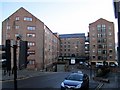
Converted warehouses, Milk Market
The old warehouses built for Jonhson, Dodds and Company have now been converted into apartments. The old alleyway of Cox Chare Image has been maintained as the narrow lane on the extreme right, between the warehouses and the Law Courts. Another of the old alleys, Love Lane, is now the gap between the warehouse buildings, but its name lives on.
This part of Newcastle's Quayside was the site of a market for dairy produce and meat recorded in 1717 but is unlikely to have been as clean and wholesome as its name suggests. It was also known as Paddy’s Market. There were other markets on the Quayside for fish, herbs, bread, cloth, leather, and clothing.
Image: © Andrew Curtis
Taken: 11 Nov 2010
0.01 miles
5
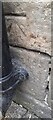
Benchmark on former warehouse on SW side of Milk Market
Ordnance Survey cut mark benchmark levelled at 8.056m above Newlyn Datum in 1962
Image: © Roger Templeman
Taken: 5 May 2022
0.01 miles
6
Love Lane
The line of the old alleyway (chare) called Love Lane is maintained between the converted warehouse buildings Image
Love Lane was the birthplace of John Scott, first Earl of Eldon and Lord Chancellor. On 18 November 1772, before his later fame, he eloped with Elizabeth (Bessie) Surtees, the daughter of a wealthy local banker, marrying against her father's wishes Image
However, unlike his birthplace in Love Lane, her house on Sandhill is still extant, and shown here Image
http://www.historyhome.co.uk/people/eldon.htm
Image: © Andrew Curtis
Taken: 18 Nov 2010
0.01 miles
7
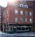
The Waterline, Milk Market
A popular pub on Newcastle's Quayside, adjacent to the converted warehouses of Milk Market Image, focus of the Dire Straits' song, 'Down to the Waterline'. There is another view here Image
Image: © Andrew Curtis
Taken: 4 Jul 2011
0.02 miles
8
Let's go down to the waterline
Dire Straits, 1978.
Image: © Mike Quinn
Taken: 13 Oct 2015
0.02 miles
9
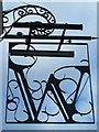
W
Image: © Mike Quinn
Taken: 13 Oct 2015
0.02 miles
10
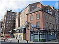
Former warehouses, Milk Market, Newcastle
Dating from around 1830. Grade II listed.
Now flats and a bar in one of them, the Waterline.
Image: © Stephen Richards
Taken: 16 Aug 2012
0.02 miles