IMAGES TAKEN NEAR TO
Roseden Way, NE13 9FE
Introduction
This page details the photographs taken nearby to Roseden Way, NE13 9FE by members of the Geograph project.
The Geograph project started in 2005 with the aim of publishing, organising and preserving representative images for every square kilometre of Great Britain, Ireland and the Isle of Man.

There are currently over 7.5m images from over14,400 individuals and you can help contribute to the project by visiting https://www.geograph.org.uk
Image Map
Images are licensed for reuse under creativecommons.org/licenses/by-sa/2.0
Notes
- Clicking on the map will re-center to the selected point.
- The higher the marker number, the further away the image location is from the centre of the postcode.
Image Listing (3 Images Found)
Images are licensed for reuse under creativecommons.org/licenses/by-sa/2.0
Image
Details
Distance
1
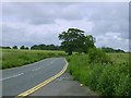
Lane/Road leading to Dinnington village
Image: © Newbiggin Hall Scouts
Taken: 24 Jun 2007
0.05 miles
3
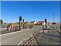
New road, Newcastle Great Park
A freshly built road on the Newcastle Great Park development. The road crosses the long-established Brunton Lane (seen on the left edge of the photo). Houses that are part of the Brunton Meadows part of the wider Great Park development can be seen further along the road.
Image: © Graham Robson
Taken: 22 Apr 2021
0.25 miles