IMAGES TAKEN NEAR TO
Daisy Field Way, NE13 9EW
Introduction
This page details the photographs taken nearby to Daisy Field Way, NE13 9EW by members of the Geograph project.
The Geograph project started in 2005 with the aim of publishing, organising and preserving representative images for every square kilometre of Great Britain, Ireland and the Isle of Man.

There are currently over 7.5m images from over14,400 individuals and you can help contribute to the project by visiting https://www.geograph.org.uk
Image Map (Loading...)


Getting Data...Please wait
Leaflet Map data © OpenStreetMap
Images are licensed for reuse under creativecommons.org/licenses/by-sa/2.0
Notes
- Clicking on the map will re-center to the selected point.
- The higher the marker number, the further away the image location is from the centre of the postcode.
Image Listing (15 Images Found)
Images are licensed for reuse under creativecommons.org/licenses/by-sa/2.0
Image
Details
Distance
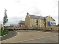
1
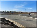
New roundabout, Newcastle Great Park
A large new roundabout has been constructed as part of a new phase of development of the Newcastle Great Park scheme. The roundabout forms part of the main east to west road through the development.
Image: © Graham Robson
Taken: 22 Apr 2021
0.07 miles
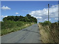
3
New road, Newcastle Great Park
A freshly built road on the Newcastle Great Park development. The road crosses the long-established Brunton Lane (seen on the left edge of the photo). Houses that are part of the Brunton Meadows part of the wider Great Park development can be seen further along the road.
Image: © Graham Robson
Taken: 22 Apr 2021
0.08 miles
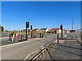
5
West Brunton Farm
Taken from road
Image: © Newbiggin Hall Scouts
Taken: 24 Jun 2007
0.12 miles
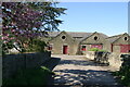
6
West Brunton Farm
Barns built in 1884 at West Brunton Farm.
Image: © Chris Bell
Taken: 29 Aug 2005
0.16 miles
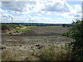
7
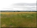
Farmland at West Brunton
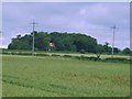
A field of barley on the edge of the Newcastle Great Park development area. The crop is turning ripe and nearing being ready to harvest.
Image: © Graham Robson
Taken: 10 Jul 2016
0.16 miles
8
West Brunton Farm
The farm was built in 1884
Image: © peter maddison
Taken: 24 Dec 2010
0.17 miles
9
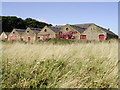
West Brunton Farm
The farm steading at West Brunton Farm Image appears to have been demolished to make way for a development of several large detached houses which are currently being built.
Image: © Graham Robson
Taken: 10 Jul 2016
0.17 miles
10
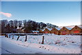
West Brunton Farm outbuildings
Viewed in 2007, these buildings were demolished to build the Brunton Square development. The date stone (1884) was recovered and has been built into the wall at the junction of the cul-de-sac and Brunton Lane.
Image: © Phil Thirkell
Taken: 30 Apr 2007
0.17 miles