IMAGES TAKEN NEAR TO
Kimmerstone Road, NEWCASTLE UPON TYNE, NE13 9AS
Introduction
This page details the photographs taken nearby to Kimmerstone Road, NE13 9AS by members of the Geograph project.
The Geograph project started in 2005 with the aim of publishing, organising and preserving representative images for every square kilometre of Great Britain, Ireland and the Isle of Man.

There are currently over 7.5m images from over14,400 individuals and you can help contribute to the project by visiting https://www.geograph.org.uk
Image Map (Loading...)


Getting Data...Please wait
Leaflet Map data © OpenStreetMap
Images are licensed for reuse under creativecommons.org/licenses/by-sa/2.0
Notes
- Clicking on the map will re-center to the selected point.
- The higher the marker number, the further away the image location is from the centre of the postcode.
Image Listing (14 Images Found)
Images are licensed for reuse under creativecommons.org/licenses/by-sa/2.0
Image
Details
Distance
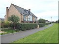
1
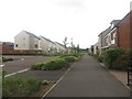
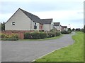
Elford Avenue, Greenside, Newcastle Great Park
Looking down a newly built residential street on the Greenside Estate. The estate is the southern most part of the Newcastle Great Park development being built on greenbelt on the north western edge of the city.
Image: © Graham Robson
Taken: 10 Jul 2016
0.09 miles
2
Shoreswood Way, Newcastle Great Park
Looking along a new residential street in the Greenside development of the Newcastle Great Park area.
Image: © Graham Robson
Taken: 10 Jul 2016
0.10 miles
3
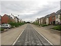
Elford Avenue, Newcastle Great Park
A newly built wide residential street in the Great Park development area.
Image: © Graham Robson
Taken: 10 Jul 2016
0.14 miles
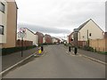
4
Rosebrough Road
Part of the new development to the north of Kingston Park.
Image: © Oliver Dixon
Taken: 2 Sep 2019
0.15 miles
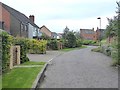
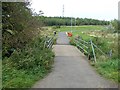
5
Rosebrough Road
Part of the new development to the north of Kingston Park.
Image: © Oliver Dixon
Taken: 2 Sep 2019
0.15 miles
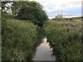
8
Bridge over the River Ouseburn
In the area of open country between the Great Park and Kingston Park developments.
Image: © Oliver Dixon
Taken: 2 Sep 2019
0.18 miles
9
Rosebrough Road
Part of the new development to the north of Kingston Park.
Image: © Oliver Dixon
Taken: 2 Sep 2019
0.19 miles
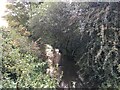
10
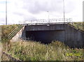
Culvert under A1 Western Bypass
This culvert carries the Ouseburn river and a public footpath under the A1.
Image: © Weston Beggard
Taken: 16 Sep 2005
0.20 miles