IMAGES TAKEN NEAR TO
Freight Village, NEWCASTLE UPON TYNE, NE13 8BH
Introduction
This page details the photographs taken nearby to Freight Village, NE13 8BH by members of the Geograph project.
The Geograph project started in 2005 with the aim of publishing, organising and preserving representative images for every square kilometre of Great Britain, Ireland and the Isle of Man.

There are currently over 7.5m images from over14,400 individuals and you can help contribute to the project by visiting https://www.geograph.org.uk
Image Map (Loading...)


Getting Data...Please wait
Leaflet Map data © OpenStreetMap
Images are licensed for reuse under creativecommons.org/licenses/by-sa/2.0
Notes
- Clicking on the map will re-center to the selected point.
- The higher the marker number, the further away the image location is from the centre of the postcode.
Image Listing (16 Images Found)
Images are licensed for reuse under creativecommons.org/licenses/by-sa/2.0
Image
Details
Distance
1
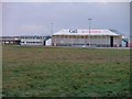
Aircraft Hangar, Newcastle Airport
2011 update: the hangar and the buildings to the left have now been demolished. The site is now occupied by the new Aviation Academy.
Image: © Mick Garratt
Taken: 26 Dec 2005
0.08 miles
2
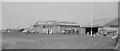
Newcastle Airport, Woolsington, 1962
A nostalgic picture taken with a pre-WWII pinhole Box Brownie camera in the days when the airport was a regular cycle ride from home.
The Newcastle Aero Club's club house is on the far right and I think the aircraft is possibly their Piper Tri-pacer. The hangar was still there when I last visited the vastly expanded modern airport terminal on the other side of the extended runway.
Image: © Chris Morgan
Taken: Unknown
0.10 miles
3
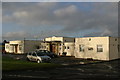
Aero Club, Wolsington (Newcastle International Airport)
The Aero Club is now based in the original Wolsington (Newcastle) Airport. [Update Oct 2011 - I have been advised that the building was demolished at the end of 2010. Looking at newspaper archives it would also appear that the Aero Club went into liquidation although I'm not sure, at this time, if it still exists!]
Image: © Phil Thirkell
Taken: 4 Jan 2006
0.14 miles
4
Entrance to Druid Park, Woolsington
Home of Newcastle Falcons Academy, Gosforth RFC, and Northumberland RU. It was formerly known as the Wheatsheaf Sports Ground and home of Newcastle Blue Star FC.
Image: © Anthony Foster
Taken: 30 May 2015
0.17 miles
5
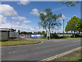
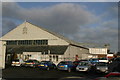
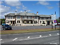
Entrance to Airview Park, Callerton
The entrance to a modern business park on the B6918 at Callerton, close to Newcastle Airport.
Image: © Graham Robson
Taken: 3 Dec 2024
0.18 miles
6
Aero Club hangar and maintenance area, Newcastle Airport
Part of the original Newcastle Airport.
Image: © Phil Thirkell
Taken: 4 Jan 2006
0.19 miles
7
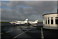
Light aircraft parked outside Aero Club
Image: © Phil Thirkell
Taken: 4 Jan 2006
0.19 miles
8
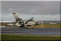
Maintenance area at Newcastle Airport
The "new" Newcastle International Airport buildings can be seen in the background (NZ1871). The jet in the foreground is a Tornado.
Image: © Phil Thirkell
Taken: 4 Jan 2006
0.19 miles
10
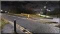
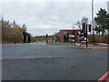
Airport Freightway
Looking along the road serving the freight terminal off Ponteland Road near Newcastle Airport.
Image: © DS Pugh
Taken: 19 Dec 2022
0.20 miles