IMAGES TAKEN NEAR TO
Green Lane, NEWCASTLE UPON TYNE, NE13 8AW
Introduction
This page details the photographs taken nearby to Green Lane, NE13 8AW by members of the Geograph project.
The Geograph project started in 2005 with the aim of publishing, organising and preserving representative images for every square kilometre of Great Britain, Ireland and the Isle of Man.

There are currently over 7.5m images from over14,400 individuals and you can help contribute to the project by visiting https://www.geograph.org.uk
Image Map
Images are licensed for reuse under creativecommons.org/licenses/by-sa/2.0
Notes
- Clicking on the map will re-center to the selected point.
- The higher the marker number, the further away the image location is from the centre of the postcode.
Image Listing (17 Images Found)
Images are licensed for reuse under creativecommons.org/licenses/by-sa/2.0
Image
Details
Distance
1
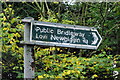
Signpost
Public bridleway signpost to Low Newbiggin Hall.
Image: © peter maddison
Taken: 10 Oct 2010
0.01 miles
2
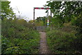
Public Footpath
Public footpath from Newbiggin Hall to Woolsington.
Image: © peter maddison
Taken: 10 Oct 2010
0.02 miles
3
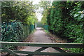
Bridleway
Public bridleway to Newbiggin Hall from Woolsington.
Image: © peter maddison
Taken: 10 Oct 2010
0.03 miles
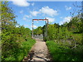
4
Metro Line at Woolsington
Your intrepid photographer risks life and limb to get this shot of the Metro tracks south of Woolsington. (I made sure there was nothing coming - but don't try this at home, kids)
Image: © Weston Beggard
Taken: 23 Oct 2005
0.03 miles
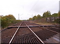
5
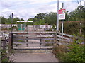
Level Crossing
This potentially injurious level crossing - no lights or warnings, but a handy reminder to 'beware of trains' - can be found spanning the Metro lines on a public bridleway between Woolsington and Low Newbiggin.
Image: © Weston Beggard
Taken: 20 Aug 2006
0.04 miles
6
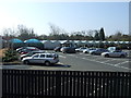
Garden centre, Woolsington
On Ponteland Road (B6918).
Image: © JThomas
Taken: 9 Apr 2015
0.05 miles
7
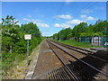
Tyne and Wear Metro at Woolsington
Part of the extension to Newcastle Airport opened in November 1991 using the alignment of the former Ponteland and Darras Hall Branch, although at this point running slightly to the south of the original line.
Image: © Anthony Foster
Taken: 30 May 2015
0.05 miles
8

Ponteland Road (B6918), Woolsington
Heading north west.
Image: © JThomas
Taken: 9 Apr 2015
0.06 miles
9
Approach to Black Lane level crossing, Woolsington
Image: © Anthony Foster
Taken: 30 May 2015
0.07 miles
10
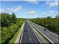
A696 Woolsington Bypass
Designed by Bullen and Partners of Durham, and built by Miller Construction the bypass opened in 1990 providing a dual carriageway from the A1 Newcastle Western Bypass - opened the same year - and Newcastle Airport, bypassing the villages of Kenton Bankfoot and Woolsington
Image: © Anthony Foster
Taken: 30 May 2015
0.17 miles