IMAGES TAKEN NEAR TO
Brunswick Industrial Estate, NEWCASTLE UPON TYNE, NE13 7GB
Introduction
This page details the photographs taken nearby to Brunswick Industrial Estate, NE13 7GB by members of the Geograph project.
The Geograph project started in 2005 with the aim of publishing, organising and preserving representative images for every square kilometre of Great Britain, Ireland and the Isle of Man.

There are currently over 7.5m images from over14,400 individuals and you can help contribute to the project by visiting https://www.geograph.org.uk
Image Map
Images are licensed for reuse under creativecommons.org/licenses/by-sa/2.0
Notes
- Clicking on the map will re-center to the selected point.
- The higher the marker number, the further away the image location is from the centre of the postcode.
Image Listing (4 Images Found)
Images are licensed for reuse under creativecommons.org/licenses/by-sa/2.0
Image
Details
Distance
1
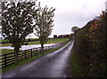
Morley Hill Farm
View shows the farmhouse at Morley Hill Farm from the end of its long driveway. The farm is just north of the Havannah Nature Reserve.
Image: © Weston Beggard
Taken: 25 Oct 2005
0.06 miles
2
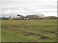
Brunswick Industrial Estate
View across arable land from Sandy Lane.
Image: © Richard Webb
Taken: 7 Mar 2009
0.06 miles
3

Wideopen hatchbacks
It's Sunday afternoon, flying in to Newcastle Airport or unloading the hatchback at Wideopen recycling centre. Wideopen is in Northumberland but the Recycling Centre is on the Brunswick Industrial Estate in Newcastle
Image: © Chris Morgan
Taken: 13 May 2018
0.22 miles
4
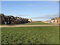
New Housing Development, Havannah Park
New development west of Hazlerigg, north of Havannah Nature Reserve
Image: © David Robinson
Taken: 20 Jan 2022
0.24 miles