IMAGES TAKEN NEAR TO
Elmwood Mews, NEWCASTLE UPON TYNE, NE13 6PW
Introduction
This page details the photographs taken nearby to Elmwood Mews, NE13 6PW by members of the Geograph project.
The Geograph project started in 2005 with the aim of publishing, organising and preserving representative images for every square kilometre of Great Britain, Ireland and the Isle of Man.

There are currently over 7.5m images from over14,400 individuals and you can help contribute to the project by visiting https://www.geograph.org.uk
Image Map (Loading...)


Getting Data...Please wait
Leaflet Map data © OpenStreetMap
Images are licensed for reuse under creativecommons.org/licenses/by-sa/2.0
Notes
- Clicking on the map will re-center to the selected point.
- The higher the marker number, the further away the image location is from the centre of the postcode.
Image Listing (21 Images Found)
Images are licensed for reuse under creativecommons.org/licenses/by-sa/2.0
Image
Details
Distance
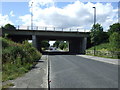
4
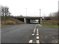
A1 bridge over Coach Lane, Hazelrigg
A modern bridge carries the northern end of the A1 Western Bypass across Coach Lane in Hazelrigg.
Image: © Graham Robson
Taken: 22 Jan 2017
0.14 miles
9
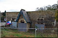
School House
School House, built in the 18th or 19th century by Thomas Eustace Smith. Location: Sandy Lane, Wideopen, North Tyneside.
Image: © peter maddison
Taken: 8 Nov 2010
0.19 miles