
IMAGES TAKEN NEAR TO
Mitford Gardens, NEWCASTLE UPON TYNE, NE13 6LU
Introduction
This page details the photographs taken nearby to Mitford Gardens, NE13 6LU by members of the Geograph project.
The Geograph project started in 2005 with the aim of publishing, organising and preserving representative images for every square kilometre of Great Britain, Ireland and the Isle of Man.

There are currently over 7.5m images from over14,400 individuals and you can help contribute to the project by visiting https://www.geograph.org.uk
Image Map
Images are licensed for reuse under creativecommons.org/licenses/by-sa/2.0
Notes
- Clicking on the map will re-center to the selected point.
- The higher the marker number, the further away the image location is from the centre of the postcode.
Image Listing (9 Images Found)
Images are licensed for reuse under creativecommons.org/licenses/by-sa/2.0
Image
Details
Distance
1

Post Box, Great North Road, Wideopen
This wall mounted post box lies on the route of the old Great North Road and is beginning to show its age.
Image: © Geoff Holland
Taken: 10 Nov 2020
0.07 miles
2
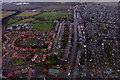
Wideopen
Wideopen, seen from the air.
Image: © Peter McDermott
Taken: 13 Nov 2008
0.13 miles
3
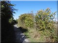
Seatonburn Waggonway
Now a path, part of the National Cycle Network, this was a mineral railway serving the colliery at Seaton Burn.
Image: © Richard Webb
Taken: 1 Oct 2015
0.14 miles
4
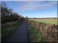
Seatonburn Waggonway
Former waggonway and later railway serving Seaton Burn colliery. The line connected with the Fawdon waggonway at Wideopen, taking coals from several collieries to the Tyne. This section of the route is now a bridleway.
Image: © David Robinson
Taken: 20 Jan 2022
0.15 miles
5
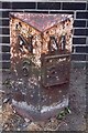
Old Milepost by the B1318, in Wideopen
Metal post with attached metal plate by the B1318, in parish of Wideopen (North Tyneside District), Great North Road, by footpath in front of blue brick wall, on East side of road. Morpeth/Newcastle iron post, erected by the Cow-causey & Buckton-Burn turnpike trust in the 19th century.
Inscription reads:-
: N / 6 : : M / 8¾ :
(To Newcastle and Morpeth)
Grade II listed.
List Entry Number: 1450225 https://historicengland.org.uk/listing/the-list/list-entry/1450225
Milestone Society National ID: NB_NCMP06
Image: © IA Davison
Taken: 7 Sep 2002
0.17 miles
6
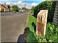
Old Milepost by the B1318, in Wideopen
Metal post with attached metal plate by the B1318, in parish of Wideopen (North Tyneside District), Great North Road, by footpath in front of blue brick wall, on East side of road. Morpeth/Newcastle iron post, erected by the Cow-causey & Buckton-Burn turnpike trust in the 19th century.
Inscription reads:-
: N / 6 : : M / 8¾ :
(To Newcastle and Morpeth)
Grade II listed.
List Entry Number: 1450225 https://historicengland.org.uk/listing/the-list/list-entry/1450225
Milestone Society National ID: NB_NCMP06
Image: © Hilary Jones
Taken: 13 Oct 2023
0.17 miles
7
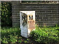
Old Milepost, Wideopen
This milepost stands on the route of the old Great North Road and has suffered further damage since IA Davison passed this way in 2002 https://www.geograph.org.uk/photo/6036014. The mileage to Morpeth has now been lost.
Image: © Geoff Holland
Taken: 10 Nov 2020
0.19 miles
9
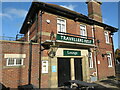
Travellers Rest Public House, Wideopen
When the first Ordnance Survey Six-Inch map of the area was published in 1864 there was a Travellers Rest (PH) located on this site although this building appears to be from a much later date. Standing alongside the old Great North Road, this site will have served passing travellers for many many years.
Image: © Geoff Holland
Taken: 10 Nov 2020
0.24 miles