IMAGES TAKEN NEAR TO
Dudley Lane, NEWCASTLE UPON TYNE, NE13 6BE
Introduction
This page details the photographs taken nearby to Dudley Lane, NE13 6BE by members of the Geograph project.
The Geograph project started in 2005 with the aim of publishing, organising and preserving representative images for every square kilometre of Great Britain, Ireland and the Isle of Man.

There are currently over 7.5m images from over14,400 individuals and you can help contribute to the project by visiting https://www.geograph.org.uk
Image Map
Images are licensed for reuse under creativecommons.org/licenses/by-sa/2.0
Notes
- Clicking on the map will re-center to the selected point.
- The higher the marker number, the further away the image location is from the centre of the postcode.
Image Listing (6 Images Found)
Images are licensed for reuse under creativecommons.org/licenses/by-sa/2.0
Image
Details
Distance
1
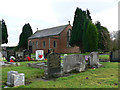
Dudley cemetery and chapel
On Dudley Lane between Seaton Burn and Dudley, south east Northumberland.
Image: © Chris Tweedy
Taken: 14 Jan 2006
0.10 miles
2
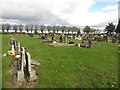
Graves in Dudley Cemetery
Some of the rows of graves in Dudley Cemetery.
Image: © Graham Robson
Taken: 8 Oct 2017
0.13 miles
3
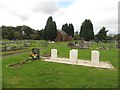
Commonwealth war graves, Dudley Cemetery
A small group of 6 Commonwealth War Graves in Dudley Cemetery. In the background is the cemetery's chapel.
Image: © Graham Robson
Taken: 8 Oct 2017
0.13 miles
4
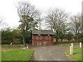
Toilets, Dudley Cemetery
A small building housing toilets in Dudley Cemetery, located on Dudley Lane between Dudley and Seaton Burn.
Image: © Graham Robson
Taken: 8 Oct 2017
0.14 miles
5
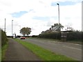
Bus stops, Dudley Lane
Bus stops on both sides of the road at Green's Houses Farm on Dudley Lane between Dudley and Seaton Burn.
Image: © Graham Robson
Taken: 8 Oct 2017
0.17 miles
6
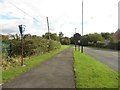
Former recycling point, Dudley Lane
An old sign marks a place where recycling bins once stood on Dudley Lane.
Image: © Graham Robson
Taken: 8 Oct 2017
0.25 miles