IMAGES TAKEN NEAR TO
Horatio Street, NEWCASTLE UPON TYNE, NE1 2PE
Introduction
This page details the photographs taken nearby to Horatio Street, NE1 2PE by members of the Geograph project.
The Geograph project started in 2005 with the aim of publishing, organising and preserving representative images for every square kilometre of Great Britain, Ireland and the Isle of Man.

There are currently over 7.5m images from over14,400 individuals and you can help contribute to the project by visiting https://www.geograph.org.uk
Image Map (352 Images)


Getting Data...Please wait
Leaflet Map data © OpenStreetMap
Images are licensed for reuse under creativecommons.org/licenses/by-sa/2.0
Notes
- Clicking on the map will re-center to the selected point.
- The higher the marker number, the further away the image location is from the centre of the postcode.
Image Listing (352 Images Found)
Images are licensed for reuse under creativecommons.org/licenses/by-sa/2.0
Image
Details
Distance
1
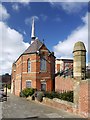
Sailor's Bethel, Horatio Street
A nonconformist chapel dedicated to resident and visiting sailors, built in 1875, now offices. There is another photo and full description here Image
Image: © Andrew Curtis
Taken: 28 Mar 2010
0.01 miles
2
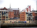
Mariner's Wharf, Sailor's Bethel & Tom Collins House
Photographed from the front of the new Jury's Inn on the Gateshead river bank. Behind Sailor's Bethel with its short pointed spire Image is Allan House (built 1908), refurbished for Hotel du Vin Image Tom Collins House, to its right, is part of the Byker Wall development and is described here Image
Image: © Andrew Curtis
Taken: 16 Feb 2012
0.01 miles
3
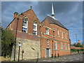
The former Sailors Bethel, Horatio Road, NE1
Originally a non-conformist sailors' chapel, it replaced an earlier building in 1877. A Sunday School was added at the rear in 1900. The building became a Danish Church after WWII, but closed in 1949. It was restored to use as offices in 1991.
Image: © Mike Quinn
Taken: 13 Oct 2015
0.01 miles
4
The former Sailors Bethel, Horatio Road, NE1 (2)
See Image
Image: © Mike Quinn
Taken: 13 Oct 2015
0.01 miles
5
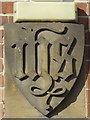
The former Sailors Bethel, Horatio Road, NE1 - inscribed stone above entrance
Image: © Mike Quinn
Taken: 13 Oct 2015
0.01 miles
6
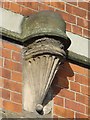
The former Sailors Bethel, Horatio Road, NE1 - detail
Image: © Mike Quinn
Taken: 13 Oct 2015
0.01 miles
7
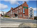
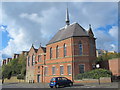
Hotel du Vin, City Road
Converted in 2007-8 from the Tyne-Tees Steam Shipping Company offices of 1908 (commonly known as Allan House). Now Hotel du Vin, hotel, restaurant and bistro. A modern wing, visible to the right, was added to the rear, off Ouse Street.
Newcastle's Victoria Tunnel runs beneath the hotel building. There is an entrance behind from Ouse Street http://en.wikipedia.org/wiki/Victoria_Tunnel_%28Newcastle%29
On the left, are the modern apartments at Lime Square with the edge of the former red-brick electricity substation just in front, now converted to offices.
The corner of the hotel wall on Ouse Street carries a Newcastle City Council commemorative plaque to the Craig family erected in 2009. The Craigs worked as watermen along the riverside in the mid C19th and came to be described in a newspaper of the time as 'the pluckiest family of lifesavers in the kingdom'. Between them they rescued about 25 people from drowning in the Rivers Tyne and Ouseburn. James Craig was known as the 'Ouseburn hero' and personally saved around 20 people. He carried out a double rescue in 1869 of both a 3 year old child and a man. He won a Royal Humane Society silver award in 1882 when, aged 53, he jumped 18 feett from a window in his home, and scaled two high walls, to save a man from drowning.
http://www.thefreelibrary.com/Tyne+heroes+to+be+honoured+at+last%3B+Group+agrees+to+have+plaque+put...-a0182020538
Image: © Andrew Curtis
Taken: 28 Mar 2010
0.03 miles
8
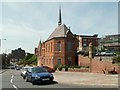
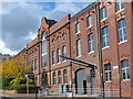
Sailors Bethel
Sailors Bethel Horatio Street, replacing an earlier building on Manor Chare, this non conformist sailors chapel, built at a cost of £2,000 to the designs of Thomas Oliver Junior, was opened 12th April 1877. The Sunday School to the rear was added in 1900. It became a Danish Church after World War II, finally closing in 1949. Restored to use as offices in 1991.
Image: © Ken Brown
Taken: 7 Jun 2005
0.03 miles
9
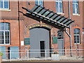
The Hotel du Vin, City Road, NE1 - detail
Image: © Mike Quinn
Taken: 13 Oct 2015
0.03 miles