IMAGES TAKEN NEAR TO
Sandgate, NEWCASTLE UPON TYNE, NE1 2NG
Introduction
This page details the photographs taken nearby to Sandgate, NE1 2NG by members of the Geograph project.
The Geograph project started in 2005 with the aim of publishing, organising and preserving representative images for every square kilometre of Great Britain, Ireland and the Isle of Man.

There are currently over 7.5m images from over14,400 individuals and you can help contribute to the project by visiting https://www.geograph.org.uk
Image Map (Loading...)


Getting Data...Please wait
Leaflet Map data © OpenStreetMap
Images are licensed for reuse under creativecommons.org/licenses/by-sa/2.0
Notes
- Clicking on the map will re-center to the selected point.
- The higher the marker number, the further away the image location is from the centre of the postcode.
Image Listing (824 Images Found)
Images are licensed for reuse under creativecommons.org/licenses/by-sa/2.0
Image
Details
Distance
1

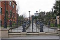
Sandgate
Sandgate on Newcastle Quayside.
Image: © Peter McDermott
Taken: 25 Sep 2011
0.02 miles
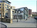
2
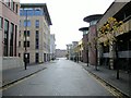
Sandgate
A quiet back lane that runs parallel to the Quayside between the new commercial and recreational developments. On the right is Quayside Multi-storey Carpark. The lane opening on the left is Swirle that leads to Image
The Pandon Burn flows below the ground here, towards the River Tyne.
Other openings reflect the old Quayside chares: Flag Chare, Anchor Chare and Wrangham's Entry.
Image: © Andrew Curtis
Taken: 11 Nov 2010
0.03 miles
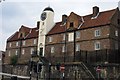
3
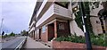
Flats on City Road, Nos. 61/63 nearest
Ordnance Survey documents indicate that a benchmark levelled at 20.388m above Newlyn Datum was verified in 1962 on the near corner of the jut on the near side of the flats
Image: © Roger Templeman
Taken: 5 May 2022
0.03 miles

5
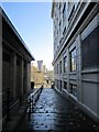
Anchor Chare, between Sandgate and Quayside
Facing the Quayside from Sandhill, as shown here, the Malmaison Hotel is on the right Image Wrangham's Entry (on the line of another chare) is on the other side of the hotel. On the left is the single-storey building that houses La Tasca and Gusto (formerly 'est est est') Italian restaurants Image Flag Chare forms a narrow lane on the other side of this building, between this and the modern Quayside House.
Image: © Andrew Curtis
Taken: 11 Nov 2010
0.04 miles
6
Pitcher and Piano
Trendy bistro on Newcastle Quayside immediately to the north of the Millennium Bridge.
Image: © Oliver Dixon
Taken: 18 Nov 2008
0.04 miles
7

'Rudder' by Andrew Burton, Keelman Square
One of two sculptures by Andrew Burton installed in 1996 flanking Keelman Square Image The other Image can be seen to its left, in front of the Malmaison Hotel.
Image: © Andrew Curtis
Taken: 18 Nov 2010
0.05 miles
8

'Column and Steps', Keelman Square
A steel sculpture by Andrew Burton, installed in 1996 for the Tyne & Wear Development Corporation. There is another photo here Image
Keelman Square was created in the new development east of the Malmaison Hotel Image in front of a new single storey building that houses two restaurants Image Anchor Chare opens on the left Image
Image: © Andrew Curtis
Taken: 18 Nov 2010
0.05 miles
9
Hospital
The Keelman's Hospital built in 1699, completed in 1701 at a cost of £2,000.
Image: © peter maddison
Taken: 29 Jul 2010
0.05 miles