IMAGES TAKEN NEAR TO
Garth Heads, NEWCASTLE UPON TYNE, NE1 2JE

Introduction

This page details the photographs taken nearby to Garth Heads, NE1 2JE by members of the Geograph project.

The Geograph project started in 2005 with the aim of publishing, organising and preserving representative images for every square kilometre of Great Britain, Ireland and the Isle of Man.

There are currently over 7.5m images from over14,400 individuals and you can help contribute to the project by visiting https://www.geograph.org.uk

Image Map


Images are licensed for reuse under creativecommons.org/licenses/by-sa/2.0
Notes
  • Clicking on the map will re-center to the selected point.
  • The higher the marker number, the further away the image location is from the centre of the postcode.

Image Listing (1145 Images Found)

Images are licensed for reuse under creativecommons.org/licenses/by-sa/2.0
  • ...
Image
Details
Distance
1
Sallyport Tower
Constructed about 1307 on the old town wall. It is presently and architect's office.
Image: © Roger Smith Taken: 21 Jul 2009
0.01 miles
2
The Keelman Hospital
Built 1701 as almshouses for keelmen and their widows.
Image: © Roger Smith Taken: 21 Jul 2009
0.01 miles
3
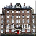
Industrial Dwellings, Garth Heads
Garth Heads Improved Housing were industrial workers dwellings, built in 1869 for the Newcastle upon Tyne Improved Industrial Dwellings Company Ltd. The building, which was extended in 1878, is probably the earliest example of philanthropic industrial housing in the city. Tyne and Wear HER (4324): Newcastle, Garth Heads Improved Housing http://www.twsitelines.info Newcastle Improved Industrial Dwellings: http://blog.twmuseums.org.uk/newcastle-improved-industrial-dwellings/
Image: © Andrew Curtis Taken: 24 Jan 2010
0.01 miles
4
George V GPO cable marker on north side of City Road at Causey Bank junction
See https://gpo-markers.derektp.co.uk/detail?post=604
Image: © Roger Templeman Taken: 5 May 2022
0.02 miles
5
Steps to Causey Bank from City Road
There is a GPO cable marker Image in the pavement against the wall of the building at the right hand side of the image
Image: © Luke Shaw Taken: 5 May 2022
0.02 miles
6
Sundial on the Keelman Hospital
Image: © Roger Smith Taken: 21 Jul 2009
0.02 miles
7
City Road
Wedge shaped building sitting between City Road (left) and Tower Street (right).
Image: © Peter McDermott Taken: 14 Oct 2007
0.02 miles
8
Benchmark on Sallyport Tower
Ordnance Survey 1GL bolt benchmark
Image: © Roger Templeman Taken: 5 May 2022
0.02 miles
9
Keelman's Hospital from Cox Chare
Cox Chare is now a road which runs from Pandon to the Quayside, to the east of the Law Courts. The hospital building is shown here Image Newcastle Libraries have a photo of Cox Chare from 1935 http://www.flickr.com/photos/newcastlelibraries/4080997796/
Image: © Andrew Curtis Taken: 11 Nov 2010
0.03 miles
10
The Keelmens Hospital, City Road, NE1
Built in 1701, for poor keelmen and keelmen's widows. The building is square, consisting of four wings around a central courtyard. It is Grade II* listed http://list.historicengland.org.uk/resultsingle.aspx?uid=1024902 . Shows the location of the Image and Image (it's below the gable beyond the clock tower).
Image: © Mike Quinn Taken: 26 May 2015
0.03 miles
  • ...