IMAGES TAKEN NEAR TO
Croft Stairs, NEWCASTLE UPON TYNE, NE1 2HG
Introduction
This page details the photographs taken nearby to Croft Stairs, NE1 2HG by members of the Geograph project.
The Geograph project started in 2005 with the aim of publishing, organising and preserving representative images for every square kilometre of Great Britain, Ireland and the Isle of Man.

There are currently over 7.5m images from over14,400 individuals and you can help contribute to the project by visiting https://www.geograph.org.uk
Image Map
Images are licensed for reuse under creativecommons.org/licenses/by-sa/2.0
Notes
- Clicking on the map will re-center to the selected point.
- The higher the marker number, the further away the image location is from the centre of the postcode.
Image Listing (1832 Images Found)
Images are licensed for reuse under creativecommons.org/licenses/by-sa/2.0
Image
Details
Distance
2
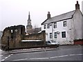
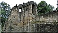
Corner Tower and Gardener?s cottage, City Road
The part of the town wall here was built after 1298 and is the last remains of the town wall on the east side.
The white-painted Gardener's Cottage was for the grounds of the halls of the Barber Surgeons who both practised as surgeons and earned extra money on the side by cutting people’s hair. The second hall on the site was demolished in 1851 to make way for the railway, running north from Central Station.
Tyne and Wear HER (1557): Newcastle town wall, Corner Tower http://www.twsitelines.info
"At distance stands an ancient tower,
Which ruin threatens every hour;
I’m struck with reverence at the sight,
I pause and gaze with fond delight;
The antique walls do join the scene,
And makes more lovely Pandon Dean."
From Pandon Dean, a song published in Sept. 1776, under the Name of Rosalinda.
http://www.gutenberg.org/files/53156/53156-h/53156-h.htm
Image: © Andrew Curtis
Taken: 15 Jan 2010
0.01 miles
3
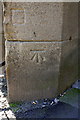
Benchmark on a buttress of Bridge ECM 7-13
Ordnance Survey cut mark benchmark described on the Bench Mark Database at http://www.bench-marks.org.uk/bm41973
Image: © Roger Templeman
Taken: 20 Jun 2012
0.01 miles
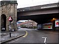
4
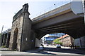
East Coast Main Line bridge ECM 7-13
There is an OS benchmark Image on the buttress on the left hand side of the road
Image: © Roger Templeman
Taken: 20 Jun 2012
0.01 miles
5
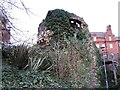
Town Wall remains
The Corner Tower on City Road, Newcastle upon Tyne
Image: © Kevin Waterhouse
Taken: 22 Aug 2020
0.01 miles
6
Railway bridge, City Road
View through to Holy Jesus Hospital Image
Image: © Andrew Curtis
Taken: 15 Jan 2010
0.01 miles
7

Ceramic tile public artwork, City Road, NE1
The location of this "space invader" is shown in Image, Image and Image Andrew Curtis's extensive set of photos of the space invaders in Newcastle is at http://www.geograph.org.uk/search.php?i=81864728 .
Image: © Mike Quinn
Taken: 5 Jun 2018
0.02 miles
8
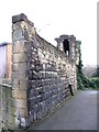
The Corner Tower, Newcastle City Walls
The blue plaque says that here there were two turrets at right angles to each other, because in the early 14th C the wall was turned east to enclose the newly acquired suburb of Pandon.
Image: © Mike Quinn
Taken: 16 Dec 2014
0.02 miles
9
(Part of) Newcastle City Walls
Looking towards Image
Image: © Mike Quinn
Taken: 16 Dec 2014
0.02 miles
10

The Corner Tower, Newcastle City Walls (2)
See Image
Image: © Mike Quinn
Taken: 16 Dec 2014
0.02 miles