IMAGES TAKEN NEAR TO
Thorntree Court, NEWCASTLE UPON TYNE, NE12 9QX
Introduction
This page details the photographs taken nearby to Thorntree Court, NE12 9QX by members of the Geograph project.
The Geograph project started in 2005 with the aim of publishing, organising and preserving representative images for every square kilometre of Great Britain, Ireland and the Isle of Man.

There are currently over 7.5m images from over14,400 individuals and you can help contribute to the project by visiting https://www.geograph.org.uk
Image Map
Images are licensed for reuse under creativecommons.org/licenses/by-sa/2.0
Notes
- Clicking on the map will re-center to the selected point.
- The higher the marker number, the further away the image location is from the centre of the postcode.
Image Listing (10 Images Found)
Images are licensed for reuse under creativecommons.org/licenses/by-sa/2.0
Image
Details
Distance
1
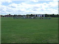
Playing field and playground
Off Bamburgh Road.
Image: © JThomas
Taken: 3 Aug 2013
0.07 miles
2
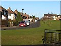
Bamburgh Road, Longbenton
Large open space and playing field to the right.
Image: © Oliver Dixon
Taken: 4 Dec 2013
0.08 miles
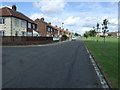
4

Open space, play area and playing field, Longbenton
A large public open space, bounded by Feetham Avenue, Bamburgh Road, Young Road and Bannister Drive.
Image: © Oliver Dixon
Taken: 4 Dec 2013
0.10 miles
7
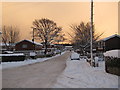
Snowy Day in Forest Hall in 2010
View East down Meadway in Forest Hall, North Tyneside
Image: © Andrew Tryon
Taken: 27 Nov 2010
0.14 miles
9

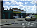
Palmersville Chippy, Bamburgh Road
A takeaway, the Palmersville Chippy, located on Bamburgh Road close to its junction with Great Lime Road.
Image: © Graham Robson
Taken: 19 Feb 2017
0.20 miles
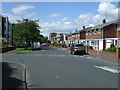
10
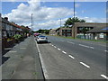
Great Lime Road (B1505)
Heading west through Palmersville.
Image: © JThomas
Taken: 3 Aug 2013
0.22 miles