IMAGES TAKEN NEAR TO
Midhurst Road, NEWCASTLE UPON TYNE, NE12 9NU
Introduction
This page details the photographs taken nearby to Midhurst Road, NE12 9NU by members of the Geograph project.
The Geograph project started in 2005 with the aim of publishing, organising and preserving representative images for every square kilometre of Great Britain, Ireland and the Isle of Man.

There are currently over 7.5m images from over14,400 individuals and you can help contribute to the project by visiting https://www.geograph.org.uk
Image Map
Images are licensed for reuse under creativecommons.org/licenses/by-sa/2.0
Notes
- Clicking on the map will re-center to the selected point.
- The higher the marker number, the further away the image location is from the centre of the postcode.
Image Listing (39 Images Found)
Images are licensed for reuse under creativecommons.org/licenses/by-sa/2.0
Image
Details
Distance
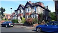
1
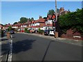
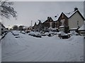
Midhurst Road, Benton
Semi-detached houses fronting on Midhurst Road in Benton.
Image: © Graham Robson
Taken: 26 Jun 2020
0.01 miles
2
Houses, Lyndhurst Road, Benton
A terrace of North Eastern Railway Cottage Homes on Lyndhurst Road. An inscribed stone in the centre of the terrace dates the construction of the block to 1926.
Image: © Graham Robson
Taken: 26 Jun 2020
0.04 miles
3
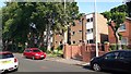
Flats on Midhurst Road, Benton
A block of flats on the south side of Midhurst Road in Benton.
Image: © Graham Robson
Taken: 26 Jun 2020
0.07 miles
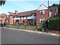
4
Houses on Midhurst Road, Benton
A pair of semi-detached houses on the southern side of Midhurst Road in Benton.
Image: © Graham Robson
Taken: 26 Jun 2020
0.10 miles
6
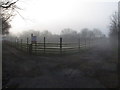
Misty morning in Forest Hall
A field at West Croft in Forest Hall
Image: © Andrew Tryon
Taken: 25 Mar 2012
0.13 miles
8

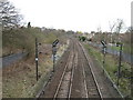
Tyne and Wear Metro Train in the Snow
A Metro train bound for St James via the Coast leaves Benton Metro Station in snowy conditions. The snowfall of November 2010 was unusually heavy and early in the Newcastle upon Tyne area.
Image: © Andrew Tryon
Taken: 28 Nov 2010
0.14 miles
9
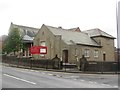
St Andrew's Church, Benton
St Andrew's is a United Reformed Church located on Station Road in Benton.
Image: © Graham Robson
Taken: 21 Aug 2016
0.15 miles
10
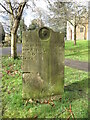
Gravestone, St. Bartholomew's Churchyard, Station Road, Benton
Whilst gravestones, or grave markers as they were more commonly known, are thought to have existed for some 3,000 years, it wasn't until the 19th century, that they started to become commonplace in society. As such, inscriptions began to become more detailed and often included a few words about the deceased. As well as more descriptive inscriptions, during the Victorian era (1837-1901), more elaborate monuments and gravestones began to appear in marble, wood, iron and granite. This gravestone pre-dates the church by 30 years although there has been a church on this site since the 9th century. For a selection of detailed free to download walking routes in the area visit www.northtynesidewalks.co.uk
Image: © Geoff Holland
Taken: 16 Mar 2021
0.15 miles