IMAGES TAKEN NEAR TO
Byland Road, NEWCASTLE UPON TYNE, NE12 8XT
Introduction
This page details the photographs taken nearby to Byland Road, NE12 8XT by members of the Geograph project.
The Geograph project started in 2005 with the aim of publishing, organising and preserving representative images for every square kilometre of Great Britain, Ireland and the Isle of Man.

There are currently over 7.5m images from over14,400 individuals and you can help contribute to the project by visiting https://www.geograph.org.uk
Image Map
Images are licensed for reuse under creativecommons.org/licenses/by-sa/2.0
Notes
- Clicking on the map will re-center to the selected point.
- The higher the marker number, the further away the image location is from the centre of the postcode.
Image Listing (15 Images Found)
Images are licensed for reuse under creativecommons.org/licenses/by-sa/2.0
Image
Details
Distance
1
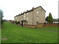
Flats on Byland Road, Longbenton, Newcastle upon Tyne
One of several blocks of flats on Byland Road at the western edge of Longbenton.
Image: © Graham Robson
Taken: 21 Aug 2016
0.05 miles
2
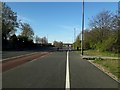
Cycle and foot paths alongside Salter's Lane
A wide and generous cycle path alongside a footpath running beside Salter's Lane. The cycle lane was added as part of wider scheme of road improvements in 2019.
Image: © Graham Robson
Taken: 7 Apr 2020
0.15 miles
3

Bus stops on Salters Lane
Bus shelters on either side of the busy Salters Lane road which connects Gosforth and Killingworth.
Image: © Graham Robson
Taken: 21 Aug 2016
0.18 miles
4
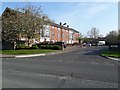
Camsey Close, Longbenton
A residential street in the Longbenton part of North Tyneside. The block of flats on the left is typical of many in the area.
Image: © Graham Robson
Taken: 25 Apr 2020
0.19 miles
5
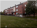
Flats, Camsey Close, Longbenton
A block of flats on the eastern side of Camsey Close in Longbenton.
Image: © Graham Robson
Taken: 5 Jun 2020
0.20 miles
6
Message to key workers, Stoneleigh Avenue, Longbenton
A chalk rainbow and message of support to 'key workers' has been added to a boundary wall facing on to Stoneleigh Avenue Image shows the surrounding context of the block of flats. During the early stages of the COVID-19 outbreak in spring 2020 messages and rainbows such as these were a common sight as people looked to publicly acknowledge the efforts of those who remained at work during the period of strictest restriction when government advice was to stay at home where ever possible.
Image: © Graham Robson
Taken: 5 Jun 2020
0.20 miles
7

Houstesteds Gardens, Longbenton
Private housing estate.
Image: © wfmillar
Taken: 13 Jul 2013
0.22 miles
8
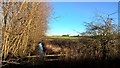
Off the course
Farmland north of Gosforth Golf Club, looking towards Killingworth Road
Image: © Chris Morgan
Taken: 20 Jan 2018
0.22 miles
9
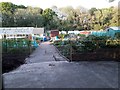
Allotment gardens, Hollywood Avenue, Gosforth, Newcastle upon Tyne
Allotment gardens off Hollywood Avenue in Gosforth.
Image: © Graham Robson
Taken: 20 May 2020
0.23 miles
