IMAGES TAKEN NEAR TO
Linden Road, NEWCASTLE UPON TYNE, NE12 8JY
Introduction
This page details the photographs taken nearby to Linden Road, NE12 8JY by members of the Geograph project.
The Geograph project started in 2005 with the aim of publishing, organising and preserving representative images for every square kilometre of Great Britain, Ireland and the Isle of Man.

There are currently over 7.5m images from over14,400 individuals and you can help contribute to the project by visiting https://www.geograph.org.uk
Image Map (Loading...)


Getting Data...Please wait
Leaflet Map data © OpenStreetMap
Images are licensed for reuse under creativecommons.org/licenses/by-sa/2.0
Notes
- Clicking on the map will re-center to the selected point.
- The higher the marker number, the further away the image location is from the centre of the postcode.
Image Listing (39 Images Found)
Images are licensed for reuse under creativecommons.org/licenses/by-sa/2.0
Image
Details
Distance
1
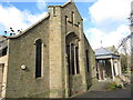
St. Andrew's Church, Station Road, Benton
This early Edwardian Church was built in 1904 and features art nouveau stained glass windows and has gothic detailing. A sandstone wall with large,
detailed gate piers forms the boundary. The contemporary extension linking the original church to the 1937-built church hall designed by Vincente Stienlet, was commended by the RIBA Hadrian Award Scheme in 2009. For a selection of detailed free to download walking routes in the area visit www.northtynesidewalks.co.uk
Image: © Geoff Holland
Taken: 16 Mar 2021
0.03 miles
2
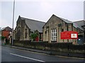
St Andrew's Methodist Church, Longbenton
Image: © Bill Henderson
Taken: 23 Jun 2007
0.03 miles
3
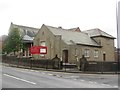
St Andrew's Church, Benton
St Andrew's is a United Reformed Church located on Station Road in Benton.
Image: © Graham Robson
Taken: 21 Aug 2016
0.04 miles
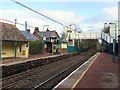
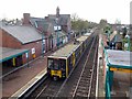
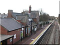
6
Benton Metro Station from footbridge
View west from the footbridge just west of Station Road, similar to Image
Image: © Andrew Curtis
Taken: 20 Nov 2015
0.05 miles
8
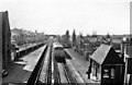
Benton Station
View westward, towards Jesmond and Newcastle; Newcastle - Manors North - Jesmond - Tynemouth (North Tyneside Electric) line, now Tyne & Wear Metro. Line de-electrified 17/6/67. Benton station closed temporarily 23/1/78, reopened as Metro station 11/8/80. (An early Diesel railcar set approaches from Newcastle).
Image: © Ben Brooksbank
Taken: 24 Mar 1970
0.05 miles
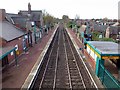
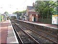
9
Benton Metro Station, Benton
This station, which forms part of the Tyne & Wear Metro System, was originally opened on 1st March 1871 and operated as part of the North Eastern Railway. The platform pictured is the western platform. For a selection of detailed free to download walking routes in the area visit www.northtynesidewalks.co.uk
Image: © Geoff Holland
Taken: 16 Mar 2021
0.06 miles
10
Benton Metro station, Tyne & Wear
Opened in 1871 by the Blyth & Tyne Railway on what later became the North Tyneside loop line from Newcastle to Tynemouth, this station was rebuilt and converted to Metro operation in 1980.
View east towards Forest Hall and Tynemouth.
Image: © Nigel Thompson
Taken: 17 Sep 2010
0.06 miles