IMAGES TAKEN NEAR TO
Radstock Place, NEWCASTLE UPON TYNE, NE12 8DD
Introduction
This page details the photographs taken nearby to Radstock Place, NE12 8DD by members of the Geograph project.
The Geograph project started in 2005 with the aim of publishing, organising and preserving representative images for every square kilometre of Great Britain, Ireland and the Isle of Man.

There are currently over 7.5m images from over14,400 individuals and you can help contribute to the project by visiting https://www.geograph.org.uk
Image Map
Images are licensed for reuse under creativecommons.org/licenses/by-sa/2.0
Notes
- Clicking on the map will re-center to the selected point.
- The higher the marker number, the further away the image location is from the centre of the postcode.
Image Listing (34 Images Found)
Images are licensed for reuse under creativecommons.org/licenses/by-sa/2.0
Image
Details
Distance
1
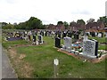
Graves, Longbenton Cemetery
Some of the many graves in Longbenton Cemetery.
Image: © Graham Robson
Taken: 18 May 2020
0.10 miles
2
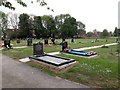
Benton Cemetery, Longbenton
An area of graves in Benton Cemetery.
Image: © Graham Robson
Taken: 18 May 2020
0.10 miles
3
Longbenton Cemetery
Graves in Longbenton Cemetery.
Image: © Graham Robson
Taken: 18 May 2020
0.11 miles
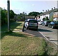
4
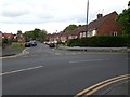
Goathland Avenue, Longbenton
A residential street in Longbenton.
Image: © Graham Robson
Taken: 18 May 2020
0.11 miles
5
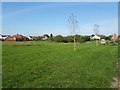
Bus turning circle, Hailsham Avenue, Longbenton
A circle for buses at the end of Hailsham Avenue in Longbenton.
Image: © Graham Robson
Taken: 14 May 2020
0.12 miles
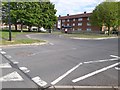
6
Benton Village Green
An area of green space known as Benton Village Green.
Image: © Graham Robson
Taken: 26 Jun 2020
0.14 miles
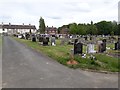
7
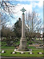
War Memorial, St. Bartholomew's Churchyard, Station Road, Benton
This First World War memorial, which is Grade II Listed, was commissioned by Longbenton Burial Board with the funds being raised by public subscription. It was unveiled at a ceremony on 6th May 1922 and dedicated by the Bishop of Durham. The eight men who died of their wounds are buried in plots arranged in an arc around the memorial and marked by commemorative tablets. For a selection of detailed free to download walking routes in the area visit www.northtynesidewalks.co.uk
Image: © Geoff Holland
Taken: 16 Mar 2021
0.14 miles
8
Bus shelter and disused toilets, Ashleigh Grove, Longbenton
A building containing a bus shelter and boarded up public toilets on Ashleigh Grove in Longbenton, beside the main entrance to Benton Cemetery.
Image: © Graham Robson
Taken: 18 May 2020
0.15 miles
9
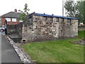
Disused toilets, Benton Cemetery
The building has the distinctive appearance of a disused toilet block and is located at the Ashleigh Grove entrance to Benton Cemetery.
Image: © Graham Robson
Taken: 18 May 2020
0.15 miles