IMAGES TAKEN NEAR TO
Grampian Place, NEWCASTLE UPON TYNE, NE12 7NX
Introduction
This page details the photographs taken nearby to Grampian Place, NE12 7NX by members of the Geograph project.
The Geograph project started in 2005 with the aim of publishing, organising and preserving representative images for every square kilometre of Great Britain, Ireland and the Isle of Man.

There are currently over 7.5m images from over14,400 individuals and you can help contribute to the project by visiting https://www.geograph.org.uk
Image Map (Loading...)


Getting Data...Please wait
Leaflet Map data © OpenStreetMap
Images are licensed for reuse under creativecommons.org/licenses/by-sa/2.0
Notes
- Clicking on the map will re-center to the selected point.
- The higher the marker number, the further away the image location is from the centre of the postcode.
Image Listing (16 Images Found)
Images are licensed for reuse under creativecommons.org/licenses/by-sa/2.0
Image
Details
Distance
1
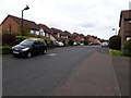
Greenhaugh, Killingworth
An estate of detached houses off Benton Road in Killingworth.
Image: © Graham Robson
Taken: 28 Apr 2020
0.08 miles
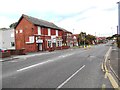
2
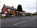
Convenience store on Benton Road, Killingworth
A small convenience store located on Benton Road.
Image: © Graham Robson
Taken: 28 Apr 2020
0.09 miles
3
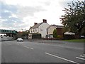
The 'George Stephenson' Public House
Image: © Bill Henderson
Taken: 20 Sep 2015
0.11 miles
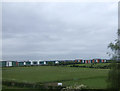
4
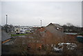
View from a Newcastle-Edinburgh train - Great Lime Road, West Moor
Image: © Nigel Thompson
Taken: 11 May 2016
0.12 miles
6
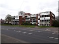
West Moor Court, Killingworth
A block of flats on Benton Lane in Killingworth.
Image: © Graham Robson
Taken: 28 Apr 2020
0.12 miles
7

The Railway Bridge over Great Lime Road, Westmoor
Image: © Bill Henderson
Taken: 11 Jun 2012
0.13 miles
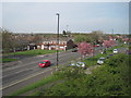
9
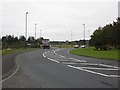
Approaching the main roundabout, West Moor
Image: © Roger Cornfoot
Taken: 11 Oct 2013
0.20 miles