IMAGES TAKEN NEAR TO
Fairfield Avenue, NEWCASTLE UPON TYNE, NE12 7LD
Introduction
This page details the photographs taken nearby to Fairfield Avenue, NE12 7LD by members of the Geograph project.
The Geograph project started in 2005 with the aim of publishing, organising and preserving representative images for every square kilometre of Great Britain, Ireland and the Isle of Man.

There are currently over 7.5m images from over14,400 individuals and you can help contribute to the project by visiting https://www.geograph.org.uk
Image Map
Images are licensed for reuse under creativecommons.org/licenses/by-sa/2.0
Notes
- Clicking on the map will re-center to the selected point.
- The higher the marker number, the further away the image location is from the centre of the postcode.
Image Listing (28 Images Found)
Images are licensed for reuse under creativecommons.org/licenses/by-sa/2.0
Image
Details
Distance
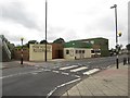
1
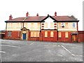
The former Police Station, Forest Hall
Image: © Bill Henderson
Taken: 20 Sep 2015
0.07 miles
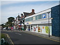
2
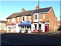
Shops, Forest Hall
On the corner of Glebe Road and Delaval Road.
Image: © Oliver Dixon
Taken: 4 Dec 2013
0.08 miles
3
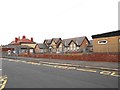
The Junior School, Delaval Road, Forest Hall
Image: © Bill Henderson
Taken: 20 Sep 2015
0.08 miles
4
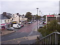
Shopping in Forest Hall
Briar Edge in Forest Hall provides most of the area's commercial amenities.
Image: © Weston Beggard
Taken: 22 Oct 2005
0.08 miles
5
The Flying Scotsman, Forest Hall
A pub situated beside the East Coast Mainline in Forest Hall.
Image: © Graham Robson
Taken: 21 Aug 2016
0.09 miles
6
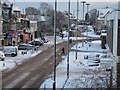
Forest Hall Shops in the Snow, 2010
Briar Edge road viewed from the footbridge that crosses the East Coast Mainline railway.
Image: © Andrew Tryon
Taken: 26 Nov 2010
0.09 miles
7
Nisa Supermarket
Laws Stores opened Forest Hall's first supermarket here in the 1960's.
Image: © Paul Franks
Taken: 23 Sep 2012
0.09 miles
8
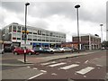
Shopping parade, Forest Hall
A suburban parade containing a variety of shops below an office building with a Sainsbury's Local supermarket at its end.
Image: © Graham Robson
Taken: 21 Aug 2016
0.10 miles
9
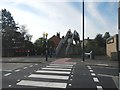
Pedestrian Crossing and Footbridge
The footbridge crosses the East Coast main railway line, and links Station Road North with Station Road. To the left of the bridge is the site of the level crossing, which was closed when Forest Hall bridge was opened in 1964. To the right is the site of Forest Hall station, closed in the 1960's.
Image: © Paul Franks
Taken: 23 Sep 2012
0.10 miles
10
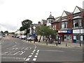
Shops, Station Road North, Forest Hall
A row of shops in a suburban area. The shops on this side of the road are opposite a similar range of shops which can be seen in: Image
Image: © Graham Robson
Taken: 21 Aug 2016
0.10 miles