IMAGES TAKEN NEAR TO
Merlay Court, NEWCASTLE UPON TYNE, NE12 7EP
Introduction
This page details the photographs taken nearby to Merlay Court, NE12 7EP by members of the Geograph project.
The Geograph project started in 2005 with the aim of publishing, organising and preserving representative images for every square kilometre of Great Britain, Ireland and the Isle of Man.

There are currently over 7.5m images from over14,400 individuals and you can help contribute to the project by visiting https://www.geograph.org.uk
Image Map (Loading...)


Getting Data...Please wait
Leaflet Map data © OpenStreetMap
Images are licensed for reuse under creativecommons.org/licenses/by-sa/2.0
Notes
- Clicking on the map will re-center to the selected point.
- The higher the marker number, the further away the image location is from the centre of the postcode.
Image Listing (18 Images Found)
Images are licensed for reuse under creativecommons.org/licenses/by-sa/2.0
Image
Details
Distance
1
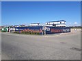
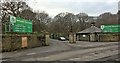
Site Compound, White House Drive, Killingworth
The main site compound on Bellway's large Moorfields development of new homes on the western edge of Killingworth.
Image: © Graham Robson
Taken: 19 Apr 2020
0.07 miles
2

New pub, White House Drive, Killingworth
This new pub, operated as a Miller & Carter Steakhouse was constructed as part of the large new development by Bellway on the western edge of Killingworth. The pub appears to be the only commercial or community property included in the development.
Image: © Graham Robson
Taken: 19 Apr 2020
0.07 miles
3
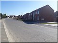
White House Drive, Killingworth
A new road created as part of Bellway's large scheme on the western edge of Killingworth.
Image: © Graham Robson
Taken: 19 Apr 2020
0.08 miles
4
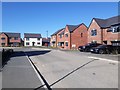
Barn Close, Killingworth
A new residential road created off White House Drive as part of Bellway's large Moorfields development on the western edge of Killingworth.
Image: © Graham Robson
Taken: 19 Apr 2020
0.09 miles
5
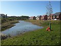
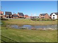
Balancing Pond, White House Drive, Killingworth
A new pond created as part of Bellway's large new development of homes on the western edge of Killingworth.
Image: © Graham Robson
Taken: 19 Apr 2020
0.09 miles
6
Houses on Barn Close, Killingworth
New houses built as part of Bellway's large Moorfields development on the western edge of Killingworth. Vehicular access is provided to the rear of the properties from Barn Close.
Image: © Graham Robson
Taken: 19 Apr 2020
0.12 miles
7
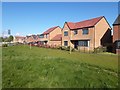
Landscaped area and new houses, White House Drive, Killingworth
As part of their large new development on the western edge of Killingworth Bellway have created a green space in the middle of the development around a balancing pond and included some soft landscaping.
Image: © Graham Robson
Taken: 19 Apr 2020
0.12 miles
9
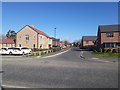
White House Drive, Killingworth
Large detached and semi detached houses stand beside the main road through the large housing scheme being constructed by Bellway Homes on the western edge of Killingworth. The homes in this part of the development have been completed, sold and are now occupied.
Image: © Graham Robson
Taken: 19 Apr 2020
0.14 miles