IMAGES TAKEN NEAR TO
Park Terrace, NEWCASTLE UPON TYNE, NE12 7EN
Introduction
This page details the photographs taken nearby to Park Terrace, NE12 7EN by members of the Geograph project.
The Geograph project started in 2005 with the aim of publishing, organising and preserving representative images for every square kilometre of Great Britain, Ireland and the Isle of Man.

There are currently over 7.5m images from over14,400 individuals and you can help contribute to the project by visiting https://www.geograph.org.uk
Image Map (Loading...)


Getting Data...Please wait
Leaflet Map data © OpenStreetMap
Images are licensed for reuse under creativecommons.org/licenses/by-sa/2.0
Notes
- Clicking on the map will re-center to the selected point.
- The higher the marker number, the further away the image location is from the centre of the postcode.
Image Listing (28 Images Found)
Images are licensed for reuse under creativecommons.org/licenses/by-sa/2.0
Image
Details
Distance
2
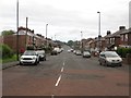
Great Lime Road, Killingworth
A long residential street in Killingworth.
Image: © Graham Robson
Taken: 21 Aug 2016
0.08 miles
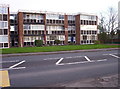
3
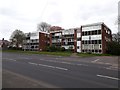
West Moor Court, Killingworth
A block of flats on Benton Lane in Killingworth.
Image: © Graham Robson
Taken: 28 Apr 2020
0.08 miles
5
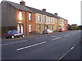
Benton Lane
A block of early 20th century terraced housing on the road into Westmoor.
Image: © Weston Beggard
Taken: 5 Nov 2005
0.11 miles
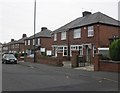
6
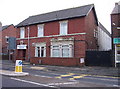
Westmoor and District Social Club
An example of a dying breed - a traditional CIU club on the Great Lime Road.
Image: © Weston Beggard
Taken: 5 Nov 2005
0.11 miles
7
West Moor Court
A 60's housing block on Benton Lane in Westmoor.
Image: © Weston Beggard
Taken: 5 Nov 2005
0.11 miles
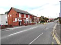
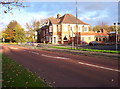
8
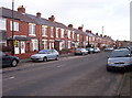
Traditional Terraces
Most towns and villages in Tyneside and Northumberland can boast at least one street of traditional workers' terraced houses, and Westmoor is no exception.
Image: © Weston Beggard
Taken: 5 Nov 2005
0.11 miles
9
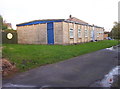
Gang Hut
This prefabricated hut, used by Cub Scouts and Brownies, is hidden in a back lane behind terraced housing.
Image: © Weston Beggard
Taken: 5 Nov 2005
0.11 miles
10
The Station
...or the 'S__TION' as it appears here. Pub so named thanks to its proximity to the old Killingworth Station.
Image: © Weston Beggard
Taken: 5 Nov 2005
0.11 miles