IMAGES TAKEN NEAR TO
Sharon Close, NEWCASTLE UPON TYNE, NE12 7EG
Introduction
This page details the photographs taken nearby to Sharon Close, NE12 7EG by members of the Geograph project.
The Geograph project started in 2005 with the aim of publishing, organising and preserving representative images for every square kilometre of Great Britain, Ireland and the Isle of Man.

There are currently over 7.5m images from over14,400 individuals and you can help contribute to the project by visiting https://www.geograph.org.uk
Image Map (Loading...)


Getting Data...Please wait
Leaflet Map data © OpenStreetMap
Images are licensed for reuse under creativecommons.org/licenses/by-sa/2.0
Notes
- Clicking on the map will re-center to the selected point.
- The higher the marker number, the further away the image location is from the centre of the postcode.
Image Listing (19 Images Found)
Images are licensed for reuse under creativecommons.org/licenses/by-sa/2.0
Image
Details
Distance
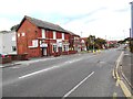
2
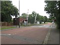
Level Crossing on the East Coast Mainline
A level crossing between Killingworth Drive and the East Coast Mainline Railway in Killingworth.
Image: © Graham Robson
Taken: 21 Aug 2016
0.11 miles

4
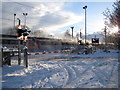
Train at a Level Crossing, North Tyneside
An intercity train bound from Newcastle to Edinburgh passes the level crossing at Killingworth in North Tyneside in heavy snow.
For a similar photo, taken further down the line the same day, see; Image
Image: © Andrew Tryon
Taken: 27 Nov 2010
0.12 miles
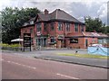
5
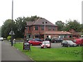
The Station, Killingworth Drive
A large pub on killingworth Drive located close to a level crossing of the road and the East Coast Mainline.
Image: © Graham Robson
Taken: 21 Aug 2016
0.13 miles
8
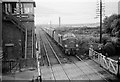
Class 40 at Killingworth level crossing
In the early days of diesel traction on the East Coast mainline, with the old Pacifics still available, but downgraded to relief engines.
Look at all those telegraph poles with multiple lines leading to the signal box. Lost now except on a few heritage railways, they connected the signal box to the boxes each side of it for the safe signalling of trains. The wires were also used to monitor the more distant signals and points by powering indicators in the box.
At this time this road was still a main A road leading to the many pit villages. Today there are sweeping dual carriageways in this south-east corner of Northumberland - and no pits! Only those with good memories can still recognise the humps in the ground where old pit heaps have been landscaped.
Picture taken from steps of footbridge at Killingworth station - all now gone, including the signal box.
Image: © Chris Morgan
Taken: Unknown
0.15 miles
9
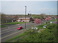
View from a Newcastle-Edinburgh train - Great Lime Road, West Moor
Image: © Nigel Thompson
Taken: 11 May 2016
0.15 miles
10
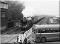
Flying Scotsman at Killingworth
Behind the train lines of sidings for coal trains are just visible.
As Flying Scotsman has two tenders I think this is on its return journey from Edinburgh soon after a non-stop run from London to Edinburgh on 1st May 1968. (Nearly ran out of water before reaching destination)
For video of outward journey see; http://www.bbc.co.uk/archive/steamtrains/7307.shtml
Image: © Chris Morgan
Taken: 25 May 1968
0.16 miles