IMAGES TAKEN NEAR TO
Stable Close, NEWCASTLE UPON TYNE, NE12 7BJ
Introduction
This page details the photographs taken nearby to Stable Close, NE12 7BJ by members of the Geograph project.
The Geograph project started in 2005 with the aim of publishing, organising and preserving representative images for every square kilometre of Great Britain, Ireland and the Isle of Man.

There are currently over 7.5m images from over14,400 individuals and you can help contribute to the project by visiting https://www.geograph.org.uk
Image Map (Loading...)


Getting Data...Please wait
Leaflet Map data © OpenStreetMap
Images are licensed for reuse under creativecommons.org/licenses/by-sa/2.0
Notes
- Clicking on the map will re-center to the selected point.
- The higher the marker number, the further away the image location is from the centre of the postcode.
Image Listing (32 Images Found)
Images are licensed for reuse under creativecommons.org/licenses/by-sa/2.0
Image
Details
Distance
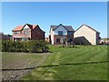
1
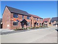
New Houses, Killingworth
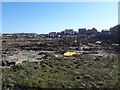
New houses on Bellway Homes' Moorfields development on farmland around White House farm in Killingworth. The development contains a mixture of three and four bedroom detached and semi-detached houses. The detached house nearest the camera still appears to being marketed for sale.
Image: © Graham Robson
Taken: 19 Apr 2020
0.01 miles
2
Bellway Homes development, Killingworth
A large new development of homes on the western edge of Killingworth being built by Bellway. A house on the left side of the new road appears to be occupied while houses on the right appear to be nearing completion.
Image: © Graham Robson
Taken: 19 Apr 2020
0.03 miles
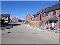
3
White House Drive, Killingworth
A newly created road in the recently completed part of a large housing development by Bellway Homes.
Image: © Graham Robson
Taken: 19 Apr 2020
0.06 miles
4
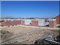
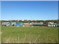
New houses under construction, Killingworth
Construction is underway on new homes in what looks like the final phase of a large development by Bellway on the western edge of Killingworth.
Image: © Graham Robson
Taken: 19 Apr 2020
0.07 miles
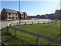
5
New housing development, Killingworth
A new housing development being constructed on the edge of Killingworth on what was, until recently, farmland surrounding White House farm.
Image: © Graham Robson
Taken: 19 Apr 2020
0.08 miles
6
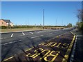
Bus stop, Killingworth Way, Killingworth
A freshly created lay by for a bus stop on the westbound side of Killingworth Way (the A1056). Across the road construction on a new housing development is underway.
Image: © Graham Robson
Taken: 19 Apr 2020
0.10 miles
7
Allotments, Gosforth Park, Newcastle
Allotments located next to the Gosforth Park Dobbies garden centre.
Image: © Graham Robson
Taken: 19 Apr 2020
0.11 miles
8
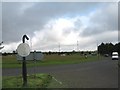
Peter Barratts Roundabout
Roundabout sponsored by Peter Barratts garden centre.
Image: © Antonia
Taken: 7 Sep 2008
0.13 miles
9
Show homes, Cygnet Park, Camperdown
The recently completed show homes in the corner of Avant Homes' new development on the western edge of Camperdown.
Image: © Graham Robson
Taken: 19 Apr 2020
0.13 miles
10
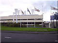
Government Offices
The Government offices of Environmental Regeneration and Housing in Killingworth.
Image: © Weston Beggard
Taken: 5 Nov 2005
0.14 miles