IMAGES TAKEN NEAR TO
Kielder Close, NEWCASTLE UPON TYNE, NE12 6TE
Introduction
This page details the photographs taken nearby to Kielder Close, NE12 6TE by members of the Geograph project.
The Geograph project started in 2005 with the aim of publishing, organising and preserving representative images for every square kilometre of Great Britain, Ireland and the Isle of Man.

There are currently over 7.5m images from over14,400 individuals and you can help contribute to the project by visiting https://www.geograph.org.uk
Image Map
Images are licensed for reuse under creativecommons.org/licenses/by-sa/2.0
Notes
- Clicking on the map will re-center to the selected point.
- The higher the marker number, the further away the image location is from the centre of the postcode.
Image Listing (11 Images Found)
Images are licensed for reuse under creativecommons.org/licenses/by-sa/2.0
Image
Details
Distance
1
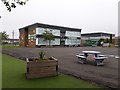
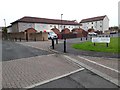
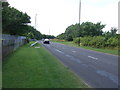
Bailey Green Primary School, West Bailey, Killingworth
A large primary school located on the north side of West Bailey in Killingworth.
Image: © Graham Robson
Taken: 13 Jun 2020
0.06 miles
2
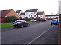
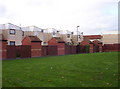
Killingworth New Town
An example of the sprawling housing stock that makes up much of central Killingworth new town.
Image: © Weston Beggard
Taken: 5 Nov 2005
0.10 miles
3
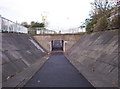
Underpass
Killingworth New Town, like virtually all British new towns of the 60's, features ill-fated experiments such as pedestrian/traffic segregation. A nice idea, but it inevitably results in hapless pedestrians having to negotiate grim concrete subways like this.
Image: © Weston Beggard
Taken: 5 Nov 2005
0.10 miles
4
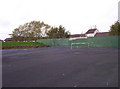
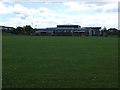
Recreation Ground
Bleak, semi-derelict recreation ground on the Killingworth housing estate.
Image: © Weston Beggard
Taken: 5 Nov 2005
0.10 miles
5
Angus Close
An example of some of the modern housing in Killingworth.
Image: © Weston Beggard
Taken: 5 Nov 2005
0.10 miles
6
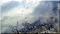
Camperdown and Killingworth from the air
Viewed from an Edinburgh-bound flight from Prague. Camperdown is to the left, Killingworth to the right, with Killingworth Way running diagonally between them. The A189 is to the left, mostly obscured by cloud.
Image: © Thomas Nugent
Taken: 22 Dec 2010
0.10 miles
8
Mallard Court, Killingworth
Short terraces of houses in Killingworth. Like the adjacent street, this one takes its name from a species of bird.
Image: © Graham Robson
Taken: 13 Jun 2020
0.16 miles
10
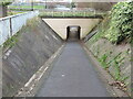
Underpass near Killingworth
This underpass links the urban sprawl of Killingworth New Town with the network of old waggonways and footpaths lying to the north. For a selection of detailed free to download walking routes in the area visit www.northtynesidewalks.co.uk
Image: © Geoff Holland
Taken: 17 Nov 2020
0.18 miles