IMAGES TAKEN NEAR TO
Moorfield Drive, NEWCASTLE UPON TYNE, NE12 6BA
Introduction
This page details the photographs taken nearby to Moorfield Drive, NE12 6BA by members of the Geograph project.
The Geograph project started in 2005 with the aim of publishing, organising and preserving representative images for every square kilometre of Great Britain, Ireland and the Isle of Man.

There are currently over 7.5m images from over14,400 individuals and you can help contribute to the project by visiting https://www.geograph.org.uk
Image Map
Images are licensed for reuse under creativecommons.org/licenses/by-sa/2.0
Notes
- Clicking on the map will re-center to the selected point.
- The higher the marker number, the further away the image location is from the centre of the postcode.
Image Listing (12 Images Found)
Images are licensed for reuse under creativecommons.org/licenses/by-sa/2.0
Image
Details
Distance
2
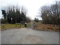
The Old Waggon Way, Killingworth
This is the entrance to footpath over the site of the old Killingworth Colliery, famous for being the workplace of George Stephenson , who was the Colliery Engineer here when he built 'The Rocket; steam engine.
Image: © Bill Henderson
Taken: 26 Feb 2018
0.17 miles
3
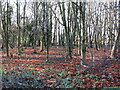
Woodland, Killingworth Village
This woodland lies next to a small car park adjacent to the route of the old Killingworth Waggonway, opened from Killingworth Colliery to Willington Quay in 1764. The waggonway, which runs gently downhill from the car park to Great Lime Road, is now a public footpath. For a selection of detailed free to download walking routes in the area visit www.northtynesidewalks.co.uk
Image: © Geoff Holland
Taken: 1 Dec 2020
0.17 miles
4
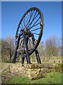
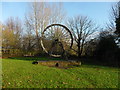
Old colliery wheel
The colliery wheel is a monument to an old pit near Killingworth and stands beside a public footpath, a former wagon-way.
Image: © Andrew Tryon
Taken: 7 Mar 2012
0.17 miles
6

Killingworth Waggonway
The origins of Killingworth Waggonway can be traced back to 1762 when it formed part of the original wooden-railed Willington Waggonway. A branch line was laid in 1806 to the Killingworth Colliery, which was sunk in 1802. By 1812 the line was referred to as the Killingworth Waggonway.
The waggonway is one of the most historically significant colliery railways within North Tyneside. During the period 1814-18 the renowned engineer, George Stephenson, tested one of the world's first steam engines, the Blucher, on the stretch between West Moor and Moor Edge.
Image: © Anthony Foster
Taken: 7 Dec 2015
0.18 miles
7
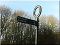
Sign near Killingworth Village
This sign points the way to Palmersville and Forest Hall along a public footpath which follows the route of the old Killingworth Waggonway. This waggonway was opened in 1764 and ran from Killingworth Colliery to Willington Quay. For a selection of detailed free to download walking routes in the area visit www.northtynesidewalks.co.uk
Image: © Geoff Holland
Taken: 1 Dec 2020
0.18 miles
8
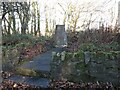
Disused Shaft, Former Killingworth Colliery
This stone marks the site of the shaft of the Killingworth High Pit (part of what was known collectively as Killingworth Colliery where George Stephenson worked as an engine wright). In 1814 George Stephenson built his first locomotive 'Blücher' with the help and encouragement of his manager, Nicholas Wood, in the colliery workshop behind his house "Dial Cottage" on Great Lime Road. And, as they say, "the rest is history". For a selection of detailed free to download walking routes in the area visit www.northtynesidewalks.co.uk. This poem, inspired by George Stephenson and the Blücher, first appeared in the 2014 published book, 'North Tyneside Steam':
KILLINGWORTH 1814/
GEORGE STEPHENSON
Canny lad,
Geordie the engine-wright,
Northumberland in his bones,
head full of bright ideas.
Cylinders, boilers, smoke stacks
& steam to haul the coal at Killingworth
where miners worked the seam.
Dust & dirt, sweat & toil
in the Colliery workshop
off the Great Lime Road.
The Blücher, a General's name,
hauled thirty tons at marching pace
down to the staithes
& the bonny Tyne.
Here he cut his teeth.
The poem was written by Geoff Holland
Image: © Geoff Holland
Taken: 1 Dec 2020
0.19 miles

10
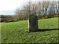
Triangulation Pillar, Killingworth Village
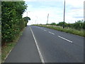
Standing at a height of 81 metres above sea level, this pillar lies next to the B1317 road between Backworth and Killingworth Village. The pillar was completed 1st August 1947 at a cost of £7.13s.0d. For a selection of detailed free to download walking routes in the area visit www.northtynesidewalks.co.uk
Image: © Geoff Holland
Taken: 1 Dec 2020
0.21 miles