IMAGES TAKEN NEAR TO
Mount Grove, GATESHEAD, NE11 9XB
Introduction
This page details the photographs taken nearby to Mount Grove, NE11 9XB by members of the Geograph project.
The Geograph project started in 2005 with the aim of publishing, organising and preserving representative images for every square kilometre of Great Britain, Ireland and the Isle of Man.

There are currently over 7.5m images from over14,400 individuals and you can help contribute to the project by visiting https://www.geograph.org.uk
Image Map (10 Images)


Getting Data...Please wait
Leaflet Map data © OpenStreetMap
Images are licensed for reuse under creativecommons.org/licenses/by-sa/2.0
Notes
- Clicking on the map will re-center to the selected point.
- The higher the marker number, the further away the image location is from the centre of the postcode.
Image Listing (10 Images Found)
Images are licensed for reuse under creativecommons.org/licenses/by-sa/2.0
Image
Details
Distance
1
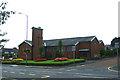
The Church of St Nicholas with Christ Church, Dunston
Image: © Bill Henderson
Taken: 19 Sep 2008
0.19 miles
3
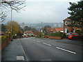
Dunston Bank
Looking down the hill towards the swimming pool. A clear day affords fantastic views of the River Tyne at Newcastle Quayside. Also in the background is Dunston Rocket.
Image: © Steve McShane
Taken: 3 Dec 2005
0.21 miles
4
Ellison Road and war memorial, Dunston
Image: © Nigel Thompson
Taken: 20 Jul 2013
0.21 miles
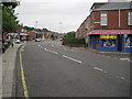
5
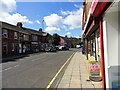
Local shops in Dunston
This is Ellison Street, at the south end of Dunston.
Image: © Robert Graham
Taken: 8 Aug 2012
0.22 miles
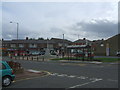
6
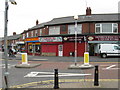
Shops on King George Avenue, Dunston Hill
Image: © Alex McGregor
Taken: 15 Apr 2010
0.22 miles
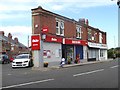
8
Looking west down Wilson Street
A street running east off Ellison Road, on the south side of Dunston. A couple of the local buses passing each other. The Go Ahead bus company paints it's vechicles different colours depending on what route they are used on, to help passengers recognize the bus they require.
Image: © Robert Graham
Taken: 8 Aug 2012
0.25 miles
9
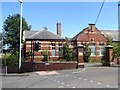
Derelict school building
This forlorn building was obviously a primary school at one time. The word "Girls" can be seen over one doorway. Presumably other doorways on the site are emblazoned with the words "Boys" and maybe even "Mixed Infants".
Image: © Oliver Dixon
Taken: 24 Jul 2019
0.25 miles
10
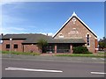
Dunston Hill Methodist Chur(c)h
The Methodist Church directly faces the Anglican church, St Nicholas with Christ Church across Ellison Road. Back in 2008, the lettering was complete (see Image).
Image: © Oliver Dixon
Taken: 24 Jul 2019
0.25 miles