IMAGES TAKEN NEAR TO
Rochester Gardens, GATESHEAD, NE11 9TH
Introduction
This page details the photographs taken nearby to Rochester Gardens, NE11 9TH by members of the Geograph project.
The Geograph project started in 2005 with the aim of publishing, organising and preserving representative images for every square kilometre of Great Britain, Ireland and the Isle of Man.

There are currently over 7.5m images from over14,400 individuals and you can help contribute to the project by visiting https://www.geograph.org.uk
Image Map (Loading...)


Getting Data...Please wait
Leaflet Map data © OpenStreetMap
Images are licensed for reuse under creativecommons.org/licenses/by-sa/2.0
Notes
- Clicking on the map will re-center to the selected point.
- The higher the marker number, the further away the image location is from the centre of the postcode.
Image Listing (49 Images Found)
Images are licensed for reuse under creativecommons.org/licenses/by-sa/2.0
Image
Details
Distance
1
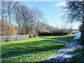
Grassed area on south side of railway
The railway is on the far side of the metal palisade fence and is passing through Dunston, part of Gateshead. A signpost tells that the route of The Keelman's Way passes through here.
Image: © Trevor Littlewood
Taken: 4 Feb 2019
0.05 miles
3
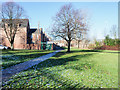
Grassed area at end of Ravensworth Terrace
Ravensworth Terrace, in Dunston, is on the north side of a railway and close to Dunston railway station. The terrace-end house at the left side of the image and those beyond form one side of the street.
Image: © Trevor Littlewood
Taken: 4 Feb 2019
0.09 miles
4
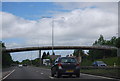
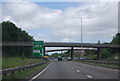
Footbridge over the A1
Linking Holmside Avenue with West Way.
Image: © Oliver Dixon
Taken: 24 Jul 2019
0.10 miles
5
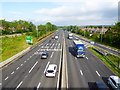
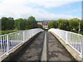
A1 Newcastle and Gateshead By-pass
Looking north-west from the Holmside Avenue footbridge.
Image: © Oliver Dixon
Taken: 24 Jul 2019
0.10 miles
6
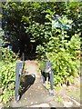
Way in to the Dunston Staithes Railway Path
A somewhat obscure path links Forge Road with the Dunston Staithes Railway Path which runs along an embankment from Eslington Park.
Image: © Oliver Dixon
Taken: 19 Sep 2017
0.10 miles
7
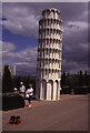
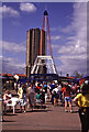
National Garden Festival, Gateshead
This Leaning tower of Pisa was located on The Boulevard linking the northern and southern parts of the site. I am unsure of the exact position so this is a best guess, at least it is on the line of The Boulevard.
Image: © Chris Allen
Taken: 30 Jul 1990
0.11 miles
8
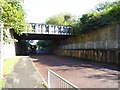
Old railway bridge over Forge Road
This substantial bridge formerly carried a railway into Dunston Staithes. It has now been converted into a hard-to-find cycle and foot path along the embankment.
Image: © Oliver Dixon
Taken: 19 Sep 2017
0.12 miles
10
National Garden Festival, Gateshead - Festival Market on the Boulevard
The boulevard was the link between the two southern sites and the two northern sites. This area was called the Festival market and included representations of the Eiffel Tower and Leaning Tower of Pisa. The location is a best guess but is aided by the tower block known locally as the Dunston Rocket. This has now been demolished.
Image: © Chris Allen
Taken: 30 Jul 1990
0.14 miles