IMAGES TAKEN NEAR TO
Meadow Close, GATESHEAD, NE11 9PQ
Introduction
This page details the photographs taken nearby to Meadow Close, NE11 9PQ by members of the Geograph project.
The Geograph project started in 2005 with the aim of publishing, organising and preserving representative images for every square kilometre of Great Britain, Ireland and the Isle of Man.

There are currently over 7.5m images from over14,400 individuals and you can help contribute to the project by visiting https://www.geograph.org.uk
Image Map (Loading...)


Getting Data...Please wait
Leaflet Map data © OpenStreetMap
Images are licensed for reuse under creativecommons.org/licenses/by-sa/2.0
Notes
- Clicking on the map will re-center to the selected point.
- The higher the marker number, the further away the image location is from the centre of the postcode.
Image Listing (13 Images Found)
Images are licensed for reuse under creativecommons.org/licenses/by-sa/2.0
Image
Details
Distance
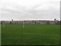
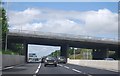
4
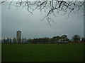
Playing Fields
A little bit of greenery amid the sprawl that is Dunston. As usual in this area of the world, the Rocket makes an appearance.
Image: © Steve McShane
Taken: 3 Dec 2005
0.16 miles
6
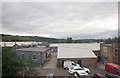
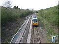
Industrial Units off Wellington Road
Looking WSW over some light industrial units off Wellington Road, from a passing train.
Image: © David P Howard
Taken: 29 Aug 2013
0.19 miles
10

Easy UpLifts
An array of MEWPs at Easy UpLifts on Wellington Road in Dunston.
Image: © Peter McDermott
Taken: 22 Aug 2010
0.24 miles