IMAGES TAKEN NEAR TO
Beech Drive, GATESHEAD, NE11 9PE
Introduction
This page details the photographs taken nearby to Beech Drive, NE11 9PE by members of the Geograph project.
The Geograph project started in 2005 with the aim of publishing, organising and preserving representative images for every square kilometre of Great Britain, Ireland and the Isle of Man.

There are currently over 7.5m images from over14,400 individuals and you can help contribute to the project by visiting https://www.geograph.org.uk
Image Map
Images are licensed for reuse under creativecommons.org/licenses/by-sa/2.0
Notes
- Clicking on the map will re-center to the selected point.
- The higher the marker number, the further away the image location is from the centre of the postcode.
Image Listing (11 Images Found)
Images are licensed for reuse under creativecommons.org/licenses/by-sa/2.0
Image
Details
Distance
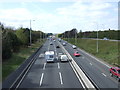
5
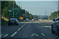
Dunston : A1
Looking north along the A1.
Image: © Lewis Clarke
Taken: 21 Sep 2020
0.20 miles
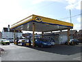
10
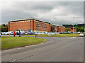
The Lancaster Suite
The Lancaster Suite, part of the former Federation Brewery site.
Image: © David Dixon
Taken: 19 Jun 2011
0.23 miles