IMAGES TAKEN NEAR TO
Pennine Gardens, GATESHEAD, NE11 9LP
Introduction
This page details the photographs taken nearby to Pennine Gardens, NE11 9LP by members of the Geograph project.
The Geograph project started in 2005 with the aim of publishing, organising and preserving representative images for every square kilometre of Great Britain, Ireland and the Isle of Man.

There are currently over 7.5m images from over14,400 individuals and you can help contribute to the project by visiting https://www.geograph.org.uk
Image Map (Loading...)


Getting Data...Please wait
Leaflet Map data © OpenStreetMap
Images are licensed for reuse under creativecommons.org/licenses/by-sa/2.0
Notes
- Clicking on the map will re-center to the selected point.
- The higher the marker number, the further away the image location is from the centre of the postcode.
Image Listing (14 Images Found)
Images are licensed for reuse under creativecommons.org/licenses/by-sa/2.0
Image
Details
Distance

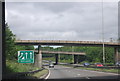
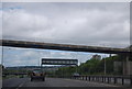
2
Approaching Lobley Hill
A1 southbound Newcastle
Image: © Les Harvey
Taken: 20 Apr 2008
0.13 miles
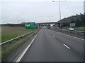
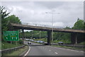
7

Dunston : A1
Looking north along the A1.
Image: © Lewis Clarke
Taken: 21 Sep 2020
0.18 miles
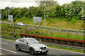
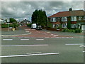
9
Bottom end of Lobley Hill
The eastern part of Lobley Hill Road, beside the flyover at the Western Bypass. The Monkey Puzzle tree over the road has been there for 60 years at least, to my knowledge.
Image: © Robert Graham
Taken: 16 Nov 2016
0.21 miles