IMAGES TAKEN NEAR TO
Moorfoot Gardens, GATESHEAD, NE11 9LB
Introduction
This page details the photographs taken nearby to Moorfoot Gardens, NE11 9LB by members of the Geograph project.
The Geograph project started in 2005 with the aim of publishing, organising and preserving representative images for every square kilometre of Great Britain, Ireland and the Isle of Man.

There are currently over 7.5m images from over14,400 individuals and you can help contribute to the project by visiting https://www.geograph.org.uk
Image Map (Loading...)


Getting Data...Please wait
Leaflet Map data © OpenStreetMap
Images are licensed for reuse under creativecommons.org/licenses/by-sa/2.0
Notes
- Clicking on the map will re-center to the selected point.
- The higher the marker number, the further away the image location is from the centre of the postcode.
Image Listing (8 Images Found)
Images are licensed for reuse under creativecommons.org/licenses/by-sa/2.0
Image
Details
Distance
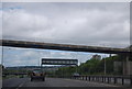
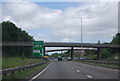
1

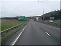
Dunston : A1
Looking north along the A1.
Image: © Lewis Clarke
Taken: 21 Sep 2020
0.18 miles
2
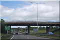
Approaching Lobley Hill
A1 southbound Newcastle
Image: © Les Harvey
Taken: 20 Apr 2008
0.18 miles
3
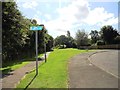
Railway Path, Gateshead
This is the start of the railway path southwards into the Durham countryside to Tanfield near Stanley. It was formerly the northern end of the Tanfield Wagonway which lead over the famous Causey Arch, carrying coals to the loading staithes on the River Tyne.
Image: © Robert Graham
Taken: 8 Aug 2012
0.18 miles

8
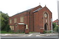
The Immaculate Heart of Mary R.C. Church
Image: © Bill Henderson
Taken: 23 Sep 2008
0.24 miles