IMAGES TAKEN NEAR TO
Dryburgh, NE11 9FP
Introduction
This page details the photographs taken nearby to Dryburgh, NE11 9FP by members of the Geograph project.
The Geograph project started in 2005 with the aim of publishing, organising and preserving representative images for every square kilometre of Great Britain, Ireland and the Isle of Man.

There are currently over 7.5m images from over14,400 individuals and you can help contribute to the project by visiting https://www.geograph.org.uk
Image Map
Images are licensed for reuse under creativecommons.org/licenses/by-sa/2.0
Notes
- Clicking on the map will re-center to the selected point.
- The higher the marker number, the further away the image location is from the centre of the postcode.
Image Listing (4 Images Found)
Images are licensed for reuse under creativecommons.org/licenses/by-sa/2.0
Image
Details
Distance
2
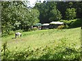
Paddock with Shire horse on Dunston Hill
Image: © Oliver Dixon
Taken: 24 Jul 2019
0.22 miles
3

Footpath to Dunston
The path from Whickham to Dunston leaves Coniston Avenue and drops down the hillside through farmland to Market Lane, Dunston.
Image: © Oliver Dixon
Taken: 24 Jul 2019
0.24 miles
4
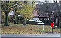
Public area with post box at corner of Coniston Avenue
The Coniston Avenue in question is in the Whickham area of Gateshead.
Image: © Trevor Littlewood
Taken: 21 Nov 2017
0.24 miles