IMAGES TAKEN NEAR TO
Drury Buildings, GATESHEAD, NE11 9DT
Introduction
This page details the photographs taken nearby to Drury Buildings, NE11 9DT by members of the Geograph project.
The Geograph project started in 2005 with the aim of publishing, organising and preserving representative images for every square kilometre of Great Britain, Ireland and the Isle of Man.

There are currently over 7.5m images from over14,400 individuals and you can help contribute to the project by visiting https://www.geograph.org.uk
Image Map (Loading...)


Getting Data...Please wait
Leaflet Map data © OpenStreetMap
Images are licensed for reuse under creativecommons.org/licenses/by-sa/2.0
Notes
- Clicking on the map will re-center to the selected point.
- The higher the marker number, the further away the image location is from the centre of the postcode.
Image Listing (110 Images Found)
Images are licensed for reuse under creativecommons.org/licenses/by-sa/2.0
Image
Details
Distance
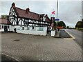
1

Tudor Rose
The Tudor Rose public house, formerly the Anchor Inn.
Image: © Peter McDermott
Taken: 12 Jun 2011
0.02 miles
2

The Tudor Rose
Local pub in Dunston, near the banks of the River Tyne.
Image: © Robert Graham
Taken: 8 Aug 2012
0.02 miles
3

Dunston Excelsior Working Men's Club, Staithes Street (2)
Image: © Mike Quinn
Taken: 5 Sep 2018
0.02 miles
4

Date stone on the Dunston Excelsior Working Men's Club, Staithes Street
The location of this date stone is shown in Image
Image: © Mike Quinn
Taken: 5 Sep 2018
0.02 miles

6

Dunston Excelsior Working Men's Club, Staithes Street
Image: © Mike Quinn
Taken: 5 Sep 2018
0.02 miles


10
The Tudor Rose pub
On Colliery Road, Dunston.
Image: © Robert Graham
Taken: 1 Jul 2024
0.02 miles