IMAGES TAKEN NEAR TO
Gibside Way, GATESHEAD, NE11 9BT
Introduction
This page details the photographs taken nearby to Gibside Way, NE11 9BT by members of the Geograph project.
The Geograph project started in 2005 with the aim of publishing, organising and preserving representative images for every square kilometre of Great Britain, Ireland and the Isle of Man.

There are currently over 7.5m images from over14,400 individuals and you can help contribute to the project by visiting https://www.geograph.org.uk
Image Map (Loading...)


Getting Data...Please wait
Leaflet Map data © OpenStreetMap
Images are licensed for reuse under creativecommons.org/licenses/by-sa/2.0
Notes
- Clicking on the map will re-center to the selected point.
- The higher the marker number, the further away the image location is from the centre of the postcode.
Image Listing (40 Images Found)
Images are licensed for reuse under creativecommons.org/licenses/by-sa/2.0
Image
Details
Distance
1
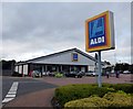
Aldi, Gateshead Metro Centre
On a small retail development South of Ikea.
Image: © David Clark
Taken: 25 Sep 2014
0.07 miles
4
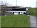
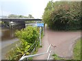
Bridges over the River Derwent
Just upstream from the confluence of the Derwent with the Tyne, the riverside path on the east bank passes under the A1114 road bridge. The bridge carrying the Newcastle to Carlisle railway can be seen beyond.
Image: © Oliver Dixon
Taken: 1 May 2013
0.11 miles
5
A major junction on the National Cycle Network
Looking south-east along the River Derwent and National Cycle Network route (Derwent Walk; National Cycle Network route 14). Towards the camera, the Keelman's Way is a riverside foot- and cycle-path which runs the full length of Gateshead Borough along the south bank of the Tyne. It is numbered NCN141 to the west of the junction, and NCN14 to the east. In the background is the bridge on Riverside Road (A1114).
Image: © Oliver Dixon
Taken: 27 Sep 2017
0.12 miles
6

Ordnance Survey Rivet
This OS rivet can be found on the wall SE end of the bridge. It marks a point 6.440m above mean sea level.
Image: © Adrian Dust
Taken: 21 Sep 2024
0.13 miles
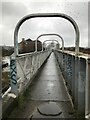
7
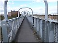
Footbridge over the River Derwent
This footbridge over the Derwent adjoins the bridge carrying the Newcastle to Carlisle railway. The footbridge carries the Keelman's Way,a foot- and cycle-path (National Cycle Network route 141) along the south bank of the Tyne. Holiday Inn Express can be seen on the far bank.
Image: © Oliver Dixon
Taken: 1 May 2013
0.13 miles
8
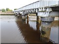
Railway bridge over the River Derwent
Bridge carrying the Carlisle to Newcastle railway over the River Derwent, immediately above its confluence with the River Tyne.
Image: © Oliver Dixon
Taken: 27 Sep 2017
0.13 miles
9
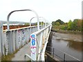
Keelman's Way bridge over the River Derwent
The Keelman's Way (National Cycle Network route 14/141) is a riverside foot- and cycle-path which runs the full length of Gateshead Borough along the south bank of the Tyne. It crosses the Derwent on a bridge shared with the Carlisle to Newcastle railway.
Image: © Oliver Dixon
Taken: 27 Sep 2017
0.13 miles
10
Derwenthaugh Railway Bridge
Showing the footpath on the south side of the bridge. See also Image] and the Bridges on the Tyne website for more info http://www.bridgesonthetyne.co.uk/dhrlwy.html
Image: © Anthony Foster
Taken: 6 Feb 2021
0.13 miles